Newfoundland and Labrador — “The Rock” and its vast mainland territory — is Canada’s most dramatically positioned province: the island of Newfoundland juts into the North Atlantic where the cold Labrador Current meets the Gulf Stream, icebergs drift past fishing villages inhabited since the 1500s, humpbacks breach within sight of St. John’s harbour, and Gros Morne National Park‘s exposed mantle rock lays the geological machinery that built the continents bare for anyone willing to walk the Tablelands trail. It is the youngest province in Confederation — Newfoundland joined in 1949 after governing itself as a British dominion — and that late, reluctant union left Newfoundlanders proudly separate in culture, accent, and outlook, a separateness the island’s isolation has guarded ever since. What survives is one of the most genuinely original regional cultures in North America: the Newfoundland English dialect, the traditional-music pubs of George Street in St. John’s, the outport communities still linked by coastal ferry, and a kitchen of salt cod, toutons (fried bread dough), and bakeapples (cloudberries) with roots in the 16th-century Basque and Portuguese fishing trade.
St. John’s: North America’s Oldest City
St. John’s — among the oldest European-founded cities on the continent, established as a fishing station in the early 1500s — is Newfoundland’s capital (about 212,000 in the metropolitan area) and the easternmost city in North America. Its geography turns on three landmarks: Signal Hill, where Marconi caught the first transatlantic wireless signal in 1901; the Narrows, the slim harbour mouth once guarded by Fort Amherst’s cannon; and the painted row houses of downtown, the “Jellybean Row” terraces that anchor every provincial tourism campaign. George Street — two short blocks that locals like to call the densest run of bars in North America — is the heart of the city’s traditional-music scene, where the Ship Inn, the Martini Bar, and the long-running Trapper John’s keep accordion, fiddle, and bodhrán going nightly, played by musicians who learned the tunes from the generation before. The Johnson Geo Centre (a geology museum dug into Signal Hill), The Rooms (the provincial museum, art gallery, and archives gathered under one clifftop roof), and Cape St. Mary’s Ecological Reserve (90 minutes out of town) round out the visitor map. Cape Spear, about 12 kilometres south of downtown and the easternmost point of North America, marks the literal edge of the continent.
Gros Morne National Park
Gros Morne National Park (1,805 km² on Newfoundland’s west coast) is the country’s most geologically important national park — a UNESCO World Heritage Site whose exposed mantle rock at the Tablelands, fjord-walled Western Brook Pond, and glacier-cut Long Range plateau add up to a landscape of rare scientific and visual weight:
- The Tablelands: the park’s signature sight — a vast, rust-coloured peridotite plateau that was once the earth’s mantle, heaved to the surface by tectonic collision about 485 million years ago as the ancient Iapetus Ocean closed; the rock’s toxic ultrabasic chemistry leaves a near-barren tableland ringed by boreal forest, and the 4 km Tablelands Trail delivers Atlantic Canada’s most striking geological walk
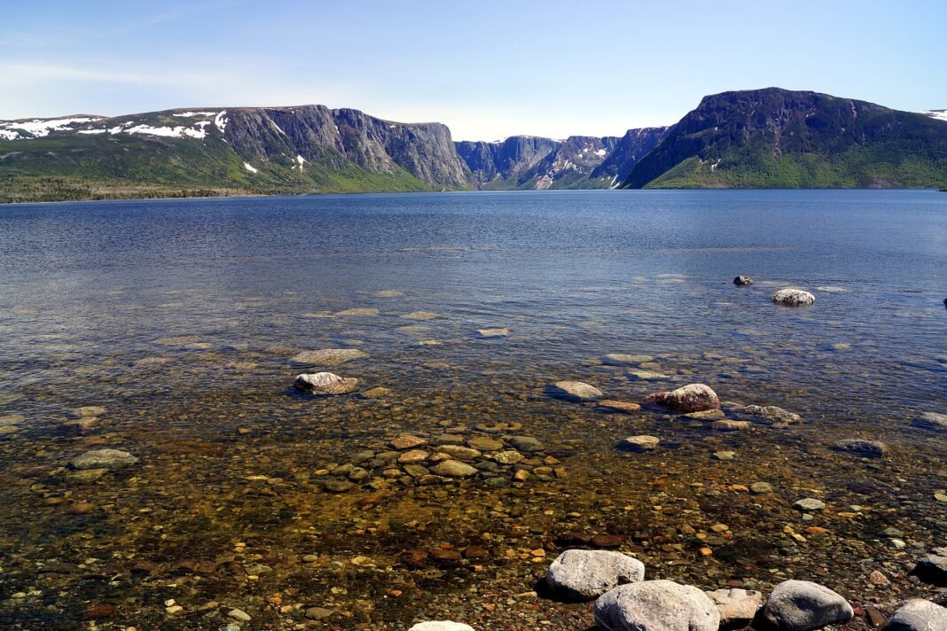
- Western Brook Pond: a landlocked fjord (technically a freshwater lake the glaciers gouged into the Long Range Mountains) and Gros Morne’s defining outing — a 3 km walk across coastal bog to the dock, then a two-hour boat tour beneath 600-metre cliffs along a gorge plunging 165 metres deep; the pairing of boat and trail makes it the park’s fullest single day
- Gros Morne Mountain: the park’s highest summit (806 m); the Ferry Gulch route (16 km return, strenuous) opens onto the Gulf of St. Lawrence, the Long Range plateau, and the Bonne Bay communities below — the toughest, and arguably the finest, day hike in the Maritimes
- Norris Point and Woody Point: the villages on Bonne Bay, the fjord that splits the park, supply lodging, dining, and sheltered sea kayaking on the tidal inlet; the summer Gros Morne Theatre Festival in Cow Head adds live performance to the mix

The Avalon Peninsula and Cape St. Mary’s
The Avalon Peninsula around St. John’s packs Newfoundland’s richest run of wildlife and coast outside Gros Morne into a couple of hours’ drive — barrens, sea stacks, puffin colonies, and the quiet of abandoned outports:
- Cape St. Mary’s Ecological Reserve: a 1 km walk from the interpretive centre leads to Bird Rock, where tens of thousands of northern gannets (around 30,000 birds, roughly 15,000 breeding pairs) crowd a sea stack cut off from the mainland by a narrow channel; the plunge-diving, the racket, and the sheer sensory weight of the colony make for one of the continent’s rawest wildlife encounters, with minke and humpback whales often passing below the cape
- Witless Bay Ecological Reserve: the islands here hold North America’s largest Atlantic puffin colony; boat tours out of Bay Bulls (35 minutes south of St. John’s) thread between them at the June–July nesting peak, when a humpback sighting is all but guaranteed
- Signal Hill National Historic Site: the bluff above the Narrows where Guglielmo Marconi received the first transatlantic wireless signal — the Morse letter “S” — in 1901; Cabot Tower at the top frames the North Atlantic, the harbour, and the Avalon coast, and the summer tattoo ceremony re-enacts the old British garrison drill
- Iceberg Alley: each spring (May–June) bergs calved from Greenland’s glaciers drift down the Newfoundland coast — a seasonal spectacle visible from shore at Twillingate, Bonavista, and the approaches to St. John’s harbour, with boat tours nosing up to ice 10,000 years old
The Viking Trail and Labrador
Past Gros Morne, the Northern Peninsula and Labrador hold the province’s most remote and history-laden ground:
- L’Anse aux Meadows National Historic Site: the only confirmed Norse settlement in North America (around 1000 CE, five centuries ahead of Columbus) at the tip of the Northern Peninsula, and a UNESCO World Heritage Site since 1978; the reconstructed turf longhouses, the interpretive centre, and the July Viking encampment make this the hemisphere’s definitive pre-Columbian European contact site, its land’s-end setting only sharpening the effect
- Red Bay National Historic Site (Labrador): a 16th-century Basque whaling station that ran the world’s busiest whale fishery through the 1570s and 1580s; the sunken galleon San Juan (lost in 1565) and the centre’s recovered artefacts paint the clearest surviving portrait of early transatlantic commerce in the Americas
- Torngat Mountains National Park: eastern Canada’s most remote park — the Inuit homeland at Labrador’s northern tip, reachable only by charter floatplane or boat; polar bears, caribou, and a wall of fjords give way to a base camp at Saglek Fjord that runs guided trips deep into genuine frontier country
Frequently Asked Questions
What makes St. John’s one of North America’s most distinctive cities?
St. John’s — the capital and largest city of Newfoundland and Labrador (about 212,000 in the metropolitan area), on the northeastern tip of the Avalon Peninsula — is one of the oldest continuously documented European harbours in North America (European fishing crews have worked these waters since the early 1500s) and is shaped by hard weather, an extraordinary physical setting, and a fiercely independent streak. The Jellybean Row houses — the brightly painted Victorian wood-frame rowhouses along Gower and Prescott Streets — are the visual emblem of the city and the most photographed streetscape in Atlantic Canada. Signal Hill National Historic Site, the clifftop above the harbour mouth where Guglielmo Marconi received the first transatlantic wireless signal in 1901, offers the region’s finest urban walking trail and views that drive home the city’s exposure to the open ocean. The George Street Entertainment District, which locals call the densest run of bars per capita of any street in North America, carries the nightlife, especially during the late-summer George Street Festival. Cape Spear — the easternmost point of North America — and Quidi Vidi Lake put wildlife and landscape within 30 minutes of downtown.
What is the outport culture of Newfoundland and why does it matter?
The outport — the small fishing community once reachable only by sea, scattered around the province’s 29,000 km of coastline — is the foundational settlement pattern of the province and the wellspring of its strongest cultural traditions: the music (Irish-influenced fiddle and accordion, unlike anything else in Canada), the dialect (Newfoundland English, shaped by Irish and West Country speech into a family of accents UNESCO has flagged as linguistically notable), and a working ethic of community self-reliance in punishing conditions. The outport network produced the most widely dispersed rural settlement in North America — more than 1,200 communities, many later emptied under the contentious resettlement programs of the 1950s and 1960s, when some 30,000 people were moved out of 300 communities. Trinity (on Trinity Bay, 200 km west of St. John’s) and Twillingate (on Notre Dame Bay, the self-styled iceberg capital of Canada) keep the fullest outport character and draw the travellers who come in search of that landscape and way of life.
What does Gros Morne National Park offer?
Gros Morne National Park — a UNESCO World Heritage Site (designated 1987), 1,805 square kilometres on the west coast of Newfoundland’s Great Northern Peninsula, 600 km from St. John’s — holds two of the continent’s landmark geological features. The Tablelands is a massive exposure of the earth’s mantle rock, peridotite forced to the surface as the ancient Iapetus Ocean closed about 485 million years ago, stained rust-red and left barren because the mantle rock poisons most plant life. Western Brook Pond is a freshwater fjord — landlocked, cut off from the sea some 9,000 years ago by glacial rebound — with 600-metre walls reached by a 3 km trail and a boat tour that ranks among the most dramatic fjord experiences in eastern North America. The Long Range Mountains, the worn Appalachian plateau that tops out at 806 m on Gros Morne Mountain, carry alpine hiking with views across the Gulf of St. Lawrence to Quebec’s Gaspésie on clear days. The community of Rocky Harbour serves as the main base, and the Discovery Centre lays out the geology behind the scenery.
What is Labrador and what does it offer?
Labrador — the mainland half of the province, 294,000 square kilometres (larger than New Zealand), linked to the island by ferry (St. Barbe to Blanc-Sablon) or by air — is one of the least-visited and most singular wilderness regions on the continent. The Labrador Coastal Highway (Route 510, the partly unpaved coastal arm of the Trans-Labrador Highway) ties together the communities of the Labrador Straits and the Happy Valley–Goose Bay area. L’Anse aux Meadows, at the tip of Newfoundland’s Great Northern Peninsula and reached from the Viking Trail, is the only confirmed Norse settlement in North America — Leif Eriksson’s Vinland, roughly 1,000 years old — and a UNESCO World Heritage Site. The Trans-Labrador Highway (about 1,150 km in total, linking Labrador City, Churchill Falls, Happy Valley–Goose Bay, and the Labrador Straits) crosses some of the emptiest, most austere terrain anywhere on the continent. Labrador City (about 9,400 people with neighbouring Wabush) is built around the Iron Ore Company of Canada’s operations, one of the country’s largest open-pit iron ore mines, set in remote boreal country.
What does Newfoundland’s food culture offer visitors and residents?
Newfoundland’s food culture stands among Canada’s most distinctive regional cooking, shaped by isolation, a maritime history, and the need to preserve food for the months when the boats stayed in. Jiggs’ dinner — salt beef boiled with turnip, carrot, potato, and cabbage, served with pease pudding — is the province’s most widely shared food ritual, the classic outport Sunday meal. Fish and brewis (salt cod and hardtack soaked overnight, then served with scrunchions of fried pork fat and drawn butter) is the dish most tied to outport survival cooking. Seal flipper pie — harp-seal flipper slow-cooked in pastry, made in spring during the seal hunt — endures well beyond any restaurant menu. The province’s dining rooms have lifted these ingredients onto the fine-dining stage: at Mallard Cottage in Quidi Vidi village and at the farm-to-table Terre in downtown St. John’s, bakeapples (cloudberries), partridgeberries, wild game, and local seafood get the treatment the tradition has long deserved.