Kansas outdoor recreation runs at Great Plains scale — vast open country, big skies, and the specific beauty of grassland ecosystems that ask for a different kind of attention than mountain or coastal landscapes do. The state’s outdoors are less famous than its neighbors’ but every bit as serious: the Flint Hills tallgrass prairie gives the Midwest one of its most important and evocative hiking environments, the state’s reservoirs deliver hundreds of miles of flatwater recreation, the chalk-formation country of western Kansas has no equivalent anywhere in the Great Plains, and the birding along the Cimarron and Arkansas River corridors rivals any inland location in the country.
.jpg?width=1200)
Tallgrass Prairie: Walking the Last Prairie
The Tallgrass Prairie National Preserve and the Konza Prairie Biological Station together protect the most accessible and most significant tracts of original tallgrass prairie left on the continent. At the National Preserve in Chase County, just outside Strong City, more than 40 miles of backcountry trails range from 4 to 13 miles across nearly 11,000 acres of protected grassland — open to day hikers without permit or fee, with no overnight camping. The routes carry you through grasses that can reach 8 feet by late summer, past limestone outcrops, across spring-fed creek drainages, and through the subtle topographic variation of the Flint Hills that belies the prairie’s reputation for flatness. The seasonal burning program — ranchers and preserve staff conduct prescribed burns in spring — keeps the fire-grass cycle that has maintained the tallgrass ecosystem for thousands of years.

The Flint Hills National Scenic Byway — 47 miles of K-177 running from Cassoday in Butler County north to Council Grove in Morris County — is the easiest way to take in the country between trailheads. Drive it in late May for the prairie wildflower bloom or in early October for the rust-and-gold turn of the warm-season grasses.
The Konza Prairie, about six miles south of Manhattan near Kansas State University, is an 8,600-acre research preserve where the Long-Term Ecological Research program has run continuously since 1981 — one of the longest-running ecological research programs in the world. Public hiking uses three loops that share a single trailhead: the Nature Trail (2.6 miles), the Kings Creek Loop (4.6 miles), and the Godwin Hill Loop (6.2 miles), each climbing from the lowland gallery forest along Kings Creek up to upland tallgrass prairie with long views across the Flint Hills. A bison herd, managed for ecological research, grazes the Konza, and trail-side encounters from a respectful distance are both possible and memorable.
.jpg?width=1200)
Monument Rocks, Castle Rock, and the Chalk Country
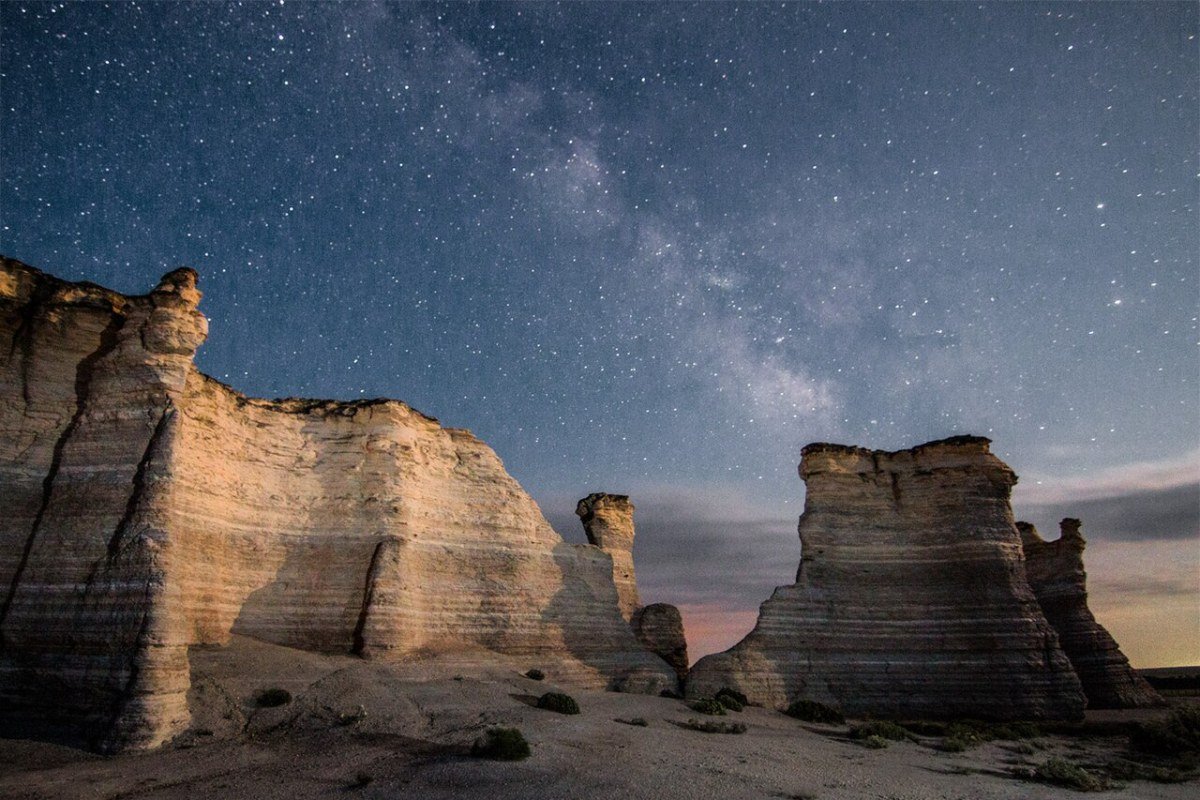
Monument Rocks (often called the Chalk Pyramids) and Castle Rock — both in Gove County in western Kansas — are the most spectacular geological features accessible to visitors in the state. The 70-foot chalk buttes, natural arches, and isolated spires rise straight out of the flat shortgrass prairie of the Smoky Hills. The chalk, part of the Smoky Hill Chalk Member of the Niobrara Formation deposited in the Cretaceous Western Interior Seaway that split North America roughly 80 million years ago, erodes into steep vertical formations wherever it’s exposed. Both sites are open to the public with no fee, no paved roads, and no facilities — drivers reach within a mile on gravel roads and then walk across the prairie to the formations. Monument Rocks was designated the first National Natural Landmark in Kansas on October 31, 1968. Without crowds or signage, the experience is one of the most genuinely surprising in the Great Plains.

Two smaller geological oddities round out the chalk and sandstone country. Mushroom Rock State Park, about 25 miles southwest of Salina near Marquette, packs a cluster of mushroom-capped Dakota sandstone formations into just five acres — at 5 acres it’s the smallest state park in Kansas, but the rocks (the largest measures 27 feet across) once served as meeting points for Plains tribes and 19th-century travelers including John C. Frémont and Kit Carson. About 3.5 miles south of Minneapolis in Ottawa County, Rock City — designated a National Natural Landmark in 1976 — holds roughly 200 calcite-cemented sandstone concretions up to 20 feet in diameter, the largest such cluster anywhere in the world. Both sites are free, take less than an hour to walk, and pair well with a Smoky Hills road-trip route.
Reservoir Recreation: Milford, Cheney, Tuttle Creek, and Beyond
Kansas has more than 20 major reservoirs managed by the U.S. Army Corps of Engineers and the Kansas Department of Wildlife and Parks (KDWP), giving the state flatwater recreation in every region. Milford Lake, near Junction City, is the largest reservoir in Kansas at roughly 15,700 acres and offers sailing, power boating, fishing (white bass, walleye, and channel catfish are the headline species), and camping along 163 miles of shoreline. Cheney Reservoir, about 20 miles west of Wichita, is the state’s premier sailing lake and supplies most of Wichita’s municipal water — close to 70% in a typical year — a role that calls for careful boat maintenance and no-wake zones near the intake structures, but pays off with the steady southwest winds that make it a leading inland sailing venue in the Midwest, with the Ninnescah Sailing Association based on the west shore.
_1.jpg?width=1200)
Tuttle Creek Reservoir, five miles north of Manhattan in the Flint Hills, is the second-largest lake in Kansas and the most scenically distinctive — 12,500 surface acres and 100 miles of shoreline ringed by the rolling limestone hills and tallgrass prairie of the Flint Hills, with fishing, camping, and the Fancy Creek Wildlife Area on the northern shore where shorebird and waterfowl habitat supports excellent birding. The Big Blue River arm of Tuttle Creek delivers flatwater kayaking through wooded bottomland that feels remote despite Manhattan’s proximity.
Three more reservoirs are worth a detour. Wilson Lake, in Russell County in the Smoky Hills, has 9,000 surface acres ringed by rugged limestone cliffs and rocky outcrops — unusual scenery for Kansas — plus one of the state’s best mountain bike trails and excellent fishing for striped bass, smallmouth bass, and walleye. Clinton Lake, four miles west of Lawrence, anchors Clinton State Park with about 380 sites, a full-service marina, and clear water that draws college-town anglers and weekenders out of Lawrence and Topeka. Perry Lake, about 20 miles northeast of Topeka, has a regional reputation as a top sailing lake, with multiple state park campgrounds and a Hobie Cove area built for catamaran launches.
Birding: The Central Flyway
Kansas sits squarely on the Central Flyway — the main migration corridor for birds moving between the central Canadian and Arctic breeding grounds and wintering grounds farther south. The Quivira National Wildlife Refuge, 22,135 acres of sand prairie and rare inland salt marsh in Stafford County, ranks among the most important shorebird staging areas in the interior of North America. In spring and fall, tens of thousands of shorebirds — including Wilson’s Phalaropes that, together with nearby Cheyenne Bottoms, make this one of the most significant interior staging grounds for the species in the country — stop at Quivira’s shallow salt marsh lakes. American Avocets, Black-necked Stilts, White-faced Ibis, and the critically endangered Whooping Crane (Quivira is designated critical habitat and one of the few places in the country where Whooping Cranes can be reliably observed during migration) use the refuge through the year. More than 340 bird species have been recorded here — a diversity usually found only along the coasts.
.jpg?width=1200)
About 30 miles north of Quivira, Cheyenne Bottoms Wildlife Area sprawls across some 41,000 acres of wetland complex northeast of Great Bend — a Ramsar Convention Wetland of International Importance and one of only a handful of inland sites in the country to hold that designation. An estimated 45% of all North American shorebirds pass through during migration, with up to 600,000 shorebirds from 39 species moving through in spring alone. Pair Cheyenne Bottoms with Quivira on the same long weekend in late April or early May for the highest shorebird counts of the year.
The Cimarron National Grassland in southwest Kansas — at roughly 108,000 acres in Morton and Stevens counties, the largest single tract of public land in the state — protects the only public shortgrass prairie and semi-arid canyon habitat in Kansas. It’s the nesting range of the Lesser Prairie-Chicken (a threatened species), the Scaled Quail, and the suite of desert-grassland birds that need conditions found nowhere else in the state. The grassland also carries 23 miles of the Santa Fe Trail — the longest stretch of the original wagon route on public land.
Cycling, Rail-Trails, and the Kaw
Kansas trail riding is centered on a handful of long-distance rail-trails and the cycling infrastructure that’s grown around Lawrence and Wichita. The Prairie Spirit Trail (51 miles from Ottawa south to Iola in eastern Kansas) was the first rails-to-trails conversion completed in the state and is now part of a much longer regional network — a crushed-limestone surface through rural prairie and farmland, paved with asphalt where it passes through Ottawa, Garnett, and Iola. It connects at Iola with the 6.5-mile Southwind Rail Trail toward Humboldt, stitching ten small prairie towns into a single ride. The Wichita bike trail network, expanding along the Arkansas River corridor and into neighborhood routes, has become one of the more ambitious urban cycling projects in the Plains states, and the Lawrence Riverfront Trail anchors the cycling culture of the college town.
For paddlers, the Kansas River Water Trail — better known locally as the Kaw — runs 173 miles from Junction City east to Kansas City and was designated the country’s second National Water Trail in 2012. Nineteen public boat ramps, sandbar camping between the high-water marks, and water-trail conditions suitable for novice boaters and families (with caution after rain or reservoir releases) make it one of the most accessible long-distance river floats in the central United States.
If you’re rolling through southeast Kansas, Big Brutus in West Mineral is worth a stop — a 16-story, 11-million-pound electric mining shovel preserved as a museum on the strip-mine country it worked from 1963 to 1974. It’s not a hike or a paddle, but it’s the kind of strange, vertical landmark that pairs well with the Mined Land Wildlife Area’s 14,500 acres of reclaimed pits now stocked for fishing and birding.
Permits, Licenses, and Planning
The Kansas Department of Wildlife and Parks (KDWP) issues all fishing and hunting licenses through gooutdoorskansas.gov. A resident annual fishing license runs $27.50, with one-day permits at $6 and a 5-year option for residents who fish regularly; nonresident annual licenses are $77.50. Residents 75 and older and those 15 and under fish and hunt without a license. State park vehicle permits ($5 daily or $25 annual) cover access to KDWP-managed parks, and camping reservations are handled through CampItKS (the state’s reservation system as of the 2026 season). Federal sites — the Tallgrass Prairie National Preserve, Quivira National Wildlife Refuge, Cimarron National Grassland, and the Corps of Engineers reservoirs — have their own (mostly free) access systems.
Kansas outdoors rewards the visitor or resident who treats it as a practitioner — who hikes the prairie with an eye for the particular grasses and wildflowers rather than searching for dramatic peaks; who paddles reservoir flatwater for the shorebird concentrations rather than whitewater thrills; who drives the chalk-formation roads of the High Plains with real curiosity about the sea that deposited them. That orientation — patient, attentive, drawn to the understated rather than the obvious showpiece — is what Kansas asks of you, and what it gives back.
Frequently Asked Questions
What makes the Tallgrass Prairie National Preserve significant for hikers?
The Tallgrass Prairie National Preserve and the Konza Prairie Biological Station together protect the most accessible and most significant tracts of original tallgrass prairie in existence. Once covering 170 million acres of North America, less than 4% of original tallgrass prairie remains, mostly in the Flint Hills of Kansas. The National Preserve, just outside Strong City in Chase County, has more than 40 miles of backcountry trails ranging from 4 to 13 miles across nearly 11,000 acres — open to day hikers without permit or fee — through grasses that reach 8 feet in late summer, past limestone outcrops, and across spring-fed creek drainages. The seasonal prescribed-burn program by ranchers and preserve staff keeps the fire-grass cycle that has sustained the tallgrass ecosystem for thousands of years. The Konza Prairie, about six miles south of Manhattan near Kansas State University, is an 8,600-acre research preserve where the Long-Term Ecological Research program has continued since 1981 — one of the world’s longest-running ecological research programs. Three public hiking loops (2.6, 4.6, and 6.2 miles) traverse the preserve, and bison encounters along the trail loops are both possible and memorable.
What are Monument Rocks and Castle Rock in Kansas?
Monument Rocks (also called the Chalk Pyramids) and Castle Rock — both in Gove County in western Kansas — are the most spectacular geological features accessible to visitors in Kansas. The 70-foot chalk buttes, natural arches, and isolated spires rise from the flat shortgrass prairie of the Smoky Hills. The chalk, part of the Smoky Hill Chalk Member of the Niobrara Formation, was deposited in the Cretaceous Western Interior Seaway that split North America roughly 80 million years ago and weathers into dramatic vertical formations wherever it’s exposed. Both sites are open to the public with no fee, no paved roads, and no facilities — visitors drive to within a mile on gravel roads and walk across the prairie to reach the formations. Monument Rocks was designated the first National Natural Landmark in Kansas on October 31, 1968. The absence of crowds and infrastructure makes these among the most genuinely surprising geological experiences in the Great Plains.
What reservoir recreation does Kansas offer?
Kansas has more than 20 major reservoirs managed by the U.S. Army Corps of Engineers and the Kansas Department of Wildlife and Parks. Milford Lake, near Junction City, is the largest in the state at roughly 15,700 acres — sailing, power boating, fishing for white bass, walleye, and channel catfish, and camping across 163 miles of shoreline. Cheney Reservoir, about 20 miles west of Wichita, is the premier sailing lake — steady southwest winds make it a leading inland sailing venue in the Midwest, with the Ninnescah Sailing Association on the west shore, and it supplies most of Wichita’s municipal water — close to 70% in a typical year. Tuttle Creek Reservoir, five miles north of Manhattan in the Flint Hills, is the second-largest lake in Kansas at 12,500 surface acres with 100 miles of shoreline through rolling limestone hills and tallgrass prairie. Wilson Lake (Russell County, Smoky Hills) brings rugged limestone-cliff scenery and excellent mountain biking; Clinton Lake (near Lawrence) anchors a 380-site state park with a full-service marina; and Perry Lake (northeast of Topeka) is a top regional sailing destination.
What makes Kansas birding along the Central Flyway significant?
Kansas sits squarely on the Central Flyway — the main migration corridor between Canadian/Arctic breeding grounds and wintering grounds farther south. The Quivira National Wildlife Refuge in Stafford County (22,135 acres of sand prairie and rare inland salt marsh) is one of the most important shorebird staging sites in interior North America. In spring and fall, tens of thousands of shorebirds — including Wilson’s Phalaropes that, together with nearby Cheyenne Bottoms, make this one of the most significant interior staging grounds for the species in the country — stop at Quivira’s shallow salt marsh lakes. American Avocets, Black-necked Stilts, White-faced Ibis, and critically endangered Whooping Cranes (Quivira is designated critical habitat) use the refuge through the year. Cheyenne Bottoms Wildlife Area, about 30 miles north of Quivira and northeast of Great Bend, is a 41,000-acre wetland complex designated a Ramsar Wetland of International Importance — roughly 45% of all North American shorebirds pass through during migration. The Cimarron National Grassland in southwest Kansas — at 108,000 acres the largest tract of public land in the state — protects the only public shortgrass prairie and semi-arid canyon habitat in Kansas, supporting the Lesser Prairie-Chicken (threatened) and Scaled Quail.
What cycling and trail opportunities does Kansas offer?
Kansas trail riding centers on a handful of long-distance rail-trails plus the cycling infrastructure around Lawrence and Wichita. The Prairie Spirit Trail (51 miles from Ottawa to Iola) was the first rails-to-trails project completed in Kansas and now links into a much longer regional network — a crushed-limestone surface through rural prairie, paved with asphalt through Ottawa, Garnett, and Iola, and connecting at Iola with the 6.5-mile Southwind Rail Trail toward Humboldt. The Wichita bike trail network, expanding along the Arkansas River corridor, has become one of the more ambitious urban cycling projects in the Plains states. The Lawrence Riverfront Trail anchors the college town’s cycling culture. For paddlers, the Kansas River Water Trail — the Kaw — runs 173 miles from Junction City to Kansas City and was the country’s second designated National Water Trail (2012), with 19 public boat ramps and sandbar camping between the high-water marks. The wide, flat terrain of Kansas makes road cycling accessible statewide during the spring and fall riding seasons.