The Australian Outback covers roughly 70% of the continent — an enormous expanse of desert, spinifex plains, ancient mountain ranges, salt lakes, and red rock country that holds some of the oldest continuous living cultures on earth and some of the most singular landscapes anywhere in the world. It’s also one of the most genuinely remote places still accessible to travellers — the silence, the scale, and the deep antiquity of the land create a shift in perspective that’s hard to find elsewhere. Visiting the Outback properly takes preparation, respect for the country and the Traditional Owners who have lived here for more than 60,000 years, and a willingness to slow right down. For travellers building a wider Aussie itinerary, the Red Centre pairs naturally with our Sydney harbour guide and the Great Barrier Reef guide on the east coast.
The Red Centre: Uluṟu, Kata Tjuṯa, and Kings Canyon
Uluṟu-Kata Tjuṯa National Park
Uluṟu is the iconic heart of the Outback — a massive sandstone inselberg (an isolated rock rising from a plain) sacred to the Aṉangu people, whose Tjukurpa (law and creation stories) is inscribed in the rock itself through art sites, waterholes, and caves visible on the base walk. The rock’s colour shifts dramatically through the day — deep red-orange at dawn, bright red through the afternoon, and extraordinary purples and magentas at sunset as the last light catches the iron-rich surface. The 10.6 km base walk around Uluṟu (around 3.5 hours) reveals the full complexity of the site: art caves, water-carved gorges, permanent waterholes (some of the few reliable water sources in the region), and the physical texture of the rock that photographs never quite capture. The shorter Mala Walk (2 km return, wheelchair accessible) follows the route of the Mala Tjukurpa past art shelters and the entry to Kantju Gorge. Climbing Uluṟu has been permanently closed since 26 October 2019, at the request of the Aṉangu Traditional Owners — the chain was removed and the path is no longer accessible.
Kata Tjuṯa (the Olgas) — 36 domed sandstone formations about 50 km west of Uluṟu — is equally spectacular and far less visited. The Valley of the Winds walk (7.4 km circuit, 3–4 hours, Grade 4 moderate-hard) threads between the domes through creek beds and lookouts that many travellers find more dramatic than Uluṟu itself; note it closes at Karu Lookout from 11 am when the forecast hits 36 °C or above. The shorter Walpa Gorge walk (2.6 km return, about 45 minutes) runs into the gorge between the two largest domes and is the right call if you’re short on time. For the most-photographed view in the whole park, the dune viewing area at sunset takes in both Uluṟu and Kata Tjuṯa in the same frame.
After dark, Field of Light — Bruce Munro’s installation of 50,000 solar-powered stems on Aṉangu Country — has been extended through to 2029 after passing its tenth anniversary; Wintjiri Wiru, the nightly drone, laser, and projection show telling a chapter of the Mala story with more than 1,100 drones, has been running since 2023 from a purpose-built platform near Yulara. The classic Sounds of Silence dinner (canapés at sunset, dinner under the stars, didgeridoo and a starlight talk) is still the textbook way to spend a night in the desert. All three are run by Voyages Indigenous Tourism Australia from Ayers Rock Resort.
Kings Canyon
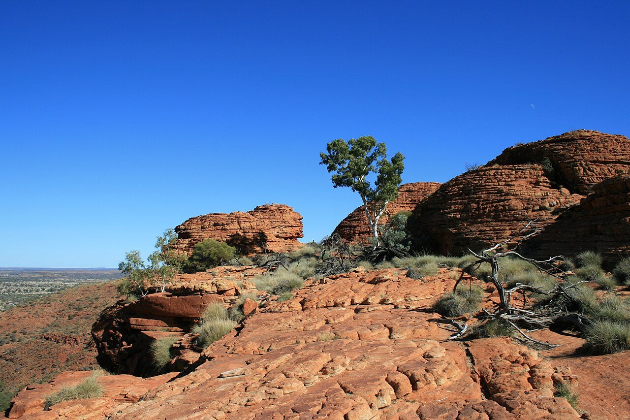
Kings Canyon in Watarrka National Park — about 300 km north of Uluṟu — is a 150-metre-deep sandstone gorge with sheer red walls, a permanent waterhole known as the Garden of Eden ringed by ancient cycad palms, and a rim walk that opens onto sweeping views across central Australia. The Kings Canyon Rim Walk (6 km loop, Grade 4, allow 3–4 hours, clockwise direction) is among the great day walks in the Outback — particularly the Lost City, a maze of weathered sandstone beehive domes on the plateau. Start before sunrise in the warmer months, carry at least 3 litres of water per person, and note the strict park rule: the walk must start before 9 am whenever the forecast temperature hits 36 °C or above (and the South Wall Walk must start before 11 am).
Alice Springs (Mparntwe) and the MacDonnell Ranges
Alice Springs — Mparntwe to the Arrernte Traditional Owners, population about 35,000 — is the main service centre of the Red Centre and a much more interesting town than first-timers expect. The Aboriginal art scene here is the real deal: Desert Mob (held annually in September at the Araluen Arts Centre) is one of Australia’s oldest First Nations art events, bringing together artists from community-owned art centres right across the desert. Papunya Tula Artists (founded in 1972 in Papunya, 240 km north-west of town, and widely credited with starting the contemporary Aboriginal art movement) is the cooperative behind the names — Clifford Possum Tjapaltjarri, Emily Kame Kngwarreye — that now sit in major collections worldwide. The Araluen Cultural Precinct (Araluen Arts Centre, Museum of Central Australia, Aviation Museum) is the cultural heart of town; Anzac Hill gives the widest overview at sunset; the Alice Springs Telegraph Station and the Royal Flying Doctor Service Tourist Facility on Stuart Terrace each repay a couple of hours.
The MacDonnell Ranges (Tjoritja), both east and west of Alice Springs, hold the finest gorge country in the centre — most of it on sealed roads, all of it free to enter:

- Simpsons Gap (24 km west): The closest gorge to town and the most reliable spot to see black-footed rock-wallabies at dawn or dusk.
- Standley Chasm (50 km west): A narrow slot canyon that glows orange-red around midday when the sun drops directly into it — aim for between 11 am and noon.
- Ellery Creek Big Hole (90 km west): A deep permanent waterhole in a wide white-walled gorge — the most popular swim in the West Macs and a great quick stop.
- Ormiston Gorge (135 km west): A ghost gum-lined waterhole up to 14 m deep, with the 7 km Ormiston Pound Walk as the standout half-day loop.
- Glen Helen Gorge (132 km west): Where the Finke River — one of the oldest watercourses on earth — cuts through the range; a permanent waterhole with rough camping nearby.
- Trephina Gorge (75 km east): A quieter, much less-visited gorge in the East Macs with a beautiful ghost gum-lined waterhole and good walking tracks.
For walkers, the Larapinta Trail runs 223 km from the Telegraph Station to Mt Sonder along the spine of the West Macs, split into 12 sections that can be hiked in pieces by day-walkers or end-to-end in roughly two weeks. Section 9 (Hugh Gorge to Ellery Creek) and the Mt Sonder summit walk are the standout day options.
Kakadu National Park: The Other Outback
Kakadu in the Northern Territory’s Top End is the largest national park in the tropics (19,804 sq km, dual-listed UNESCO World Heritage for both natural and cultural values) and a completely different Outback landscape from the Red Centre — monsoonal, extraordinary for birdlife, and holding the most significant body of Aboriginal rock art in the world. The rock art sites at Ubirr and Burrungkuy (Nourlangie) span more than 20,000 years of continuous occupation and record everything from thylacines (Tasmanian tigers, now extinct on the mainland) to “contact art” depicting European sailing ships. Kakadu’s floodplains carry an astonishing amount of birdlife — jabiru, brolgas, magpie geese in their hundreds of thousands during the dry season, sea eagles, red-tailed black cockatoos. The Yellow Water dawn cruise (Cooinda, daily, book ahead) is the standout wildlife outing in the park. The window to visit runs May to October (dry season, roads open, wildlife concentrated near remaining water).

Beyond the Centre: Coober Pedy, the Ghan, and Mungo
The Outback runs well past the Northern Territory. Coober Pedy, about 850 km north of Adelaide and 750 km south of Uluṟu on the Stuart Highway, is the opal capital of the world and famously lives underground — about half the town’s roughly 1,700 residents live in “dugouts” carved into the hillsides to escape summer heat that routinely tops 45 °C. Tour an underground home, sleep in a dugout hotel, and walk the surface of the Breakaways, a lunar-looking range of weathered stone breakaways on the edge of town. Mungo National Park in far-western New South Wales is a World Heritage-listed dry lake bed where Mungo Man and Mungo Lady — among the oldest human remains found outside Africa, with Mungo Man dated to around 40,000 years — were uncovered; the Walls of China dunes glow in late afternoon light. The Ghan long-distance train links Adelaide to Darwin via Alice Springs in two nights (54 hours northbound, including off-train excursions), one of the great rail journeys anywhere. For more on the South Australian side, see our South Australia travel guide, and the Western Australia guide for the Kimberley and Karijini.
Essential Safety in the Outback
The Outback is profoundly remote, and the consequences of being unprepared are serious. These aren’t suggestions — they’re requirements:
- Water: Carry a minimum of 4 litres per person per day for any activity — more in summer or on strenuous walks. Never rely on waterholes being accessible or drinkable. Keep emergency water in the vehicle at all times.
- Vehicle: For remote tracks (anything beyond the main sealed roads), a 4WD with high clearance is required. Carry two spare tyres (not one), a recovery board, a high-lift jack, jumper leads, and enough fuel between stops to clear the longest gap. Check that your hire agreement actually permits off-road driving — most don’t, by default.
- Communication: Mobile coverage is non-existent across most of the Outback. A personal locator beacon (PLB) or satellite communicator (Garmin inReach, ZOLEO, SPOT) is essential for remote travel. Hire from park visitor centres or the NT Police if needed.
- Tell someone: File a detailed itinerary with someone reliable before heading into remote country, and stick to it. If you break down, stay with the vehicle — it’s far easier to find than a person on foot.
- Heat: Temperatures can reach 48–50 °C in the Red Centre in December and January. Don’t hike or undertake outdoor activity between 10 am and 4 pm in summer. May–September is by far the prime window for Outback travel; April and October are the shoulder.
- Wildlife: Most of Australia’s most venomous snakes live in the Outback. Watch where you put hands and feet, particularly around rocks, logs, and long grass, and shake out shoes and clothing left outside overnight. Dingoes, red kangaroos, and the occasional thorny devil are the rewards for paying attention.
- Permits and country: Some areas — including parts of the Mereenie Loop and most Aboriginal land outside the national parks — require a permit from the relevant land council. Sort this before you go, not at the gate.
Frequently Asked Questions
What’s the experience of visiting Uluṟu and Kata Tjuṯa?
Uluṟu is a 348-metre sandstone monolith rising out of the flat Central Australian plain — one of the most immediately arresting natural sights anywhere on earth. The climb was permanently closed on 26 October 2019 at the request of the Aṉangu Traditional Owners, for whom the rock is deeply sacred; the 10.6 km base walk (around 3.5 hours) takes in the art sites, waterholes, caves, and ceremonial places that ring its base, and the shorter 2 km wheelchair-accessible Mala Walk follows part of the Mala Tjukurpa. Sunrise and sunset light shows — as the rock cycles through reds, oranges, purples, and pinks — are best caught from the dedicated platforms (Talinguru Nyakunytjaku at sunrise, the car sunset viewing area in the afternoon). Kata Tjuṯa (the Olgas), 50 km west, is 36 domed rock formations covering 21.68 sq km, and plenty of travellers find it beats Uluṟu for sheer drama. The Valley of the Winds walk (7.4 km circuit, Grade 4) threads the gorges between the domes through some of the wildest country in central Australia.
What is Kings Canyon and how does the Rim Walk work?
Kings Canyon in Watarrka National Park is one of the most dramatic gorge landscapes in Australia — sheer sandstone walls about 150 metres high enclosing the Garden of Eden, a permanent waterhole surrounded by Livistona mariae cycad palms found nowhere else. The Kings Canyon Rim Walk (6 km loop, Grade 4, 3–4 hours, clockwise only) begins with a steep climb up the canyon wall, then follows the plateau rim above the gorge before descending through the Garden of Eden and the beehive sandstone domes of the Lost City. The walk must start before 9 am whenever the forecast temperature reaches 36 °C or above — a strict park rule that applies roughly from October through March. Kings Canyon Resort is the only accommodation at the canyon itself; the campground next door is cheaper and just as well placed. The canyon sits 300 km from Uluṟu and around 460 km from Alice Springs via the sealed Lasseter and Luritja highways, which makes it a logical second stop on a Red Centre circuit.
What makes Kakadu National Park exceptional?
Kakadu National Park spans 19,804 sq km in the Top End and is dual-listed on the UNESCO World Heritage List for both natural and cultural values — one of only a handful of sites in the world to hold that double listing. The Yellow Water Billabong cruise out of Cooinda at dawn or dusk ranks among the finest wildlife outings in Australia — saltwater crocodiles basking on the banks (the biggest reaching 5–6 metres), jabiru storks, sea eagles, and kingfishers across a wetland of extraordinary richness. Ubirr and Burrungkuy (Nourlangie) preserve paintings dating back at least 20,000 years, depicting Mimi spirits, creation figures, and hunting scenes — the most accessible, best-interpreted Aboriginal rock art in the country. Jim Jim Falls (a roughly 200-metre plunge) and Twin Falls are 4WD-only and dry-season only. Best time to visit is May to September (dry); the wet season (December to March) is partial closure but transforms the landscape and is well worth a return trip.
What safety precautions are essential in the Australian Outback?
The Outback is unforgiving without proper preparation — every year a handful of visitors die from dehydration, heat exhaustion, and vehicle breakdowns in country with no mobile coverage. Water is non-negotiable: minimum 4 litres per person per day, plus emergency reserves in the vehicle. A Personal Locator Beacon (PLB) or satellite communicator (Garmin inReach, ZOLEO, SPOT) is strongly recommended for anything beyond sealed roads — there’s no mobile signal across most of the Outback. Lodge your itinerary with the relevant state or territory police before you head out. A 4WD with high ground clearance is required for most unsealed Outback tracks, although a standard 2WD is fine for the sealed roads linking Uluṟu, Kings Canyon, and Alice Springs. Tell someone your route and expected return — if you break down, stay with the vehicle, which is far easier to spot than a person walking in open country. Temperatures routinely top 45 °C in summer (November to March), so plan desert walks for before 9 am and avoid the 11 am–4 pm window altogether.
What cultural experiences does the Central Australian Outback offer?
Central Australia has the highest concentration of living Aboriginal culture accessible to visitors anywhere in the country. The Aṉangu Pitjantjatjara Yankunytjatjara people have held continuous connection to the Uluṟu region for tens of thousands of years, and guided cultural walks with Aṉangu guides (through SEIT Outback Australia and Maruku Arts among others) are the surest way to read the landscape — a base walk with an Aṉangu guide turns the rock from a scenic attraction into a living cultural document. Papunya Tula Artists (established in 1972 in Papunya, Western Desert) is the founding cooperative of the Aboriginal painting movement that put Central Australian art on the world stage, with work by Clifford Possum Tjapaltjarri and Emily Kame Kngwarreye commanding major auction prices. Alice Springs is the regional hub: the Araluen Cultural Precinct, the Museum of Central Australia, and Alice Springs Desert Park (about 2,000 desert animals in natural habitats) give the context. West of town, the Tjoritja / West MacDonnell Ranges (Ormiston Gorge, Standley Chasm, Ellery Creek Big Hole) deliver excellent walking and swimming in gorge waterholes.