The Yukon — Canada’s westernmost territory, wedged between Alaska, British Columbia, and the Northwest Territories at the continent’s northwestern corner — is the product of two defining events: the Klondike Gold Rush of 1897-1898, which briefly made Dawson City one of the largest settlements west of Chicago and north of San Francisco, and the Alaska Highway, built by the US Army in 1942 in eight months of remarkable engineering effort, which for the first time connected the Yukon to southern Canada by road. Both events shaped the territory irreversibly: the Gold Rush left a cultural legacy of frontier mythology and human history embedded in a landscape of subarctic beauty; the Alaska Highway created the spine of the territory’s modern economy, allowing Whitehorse to grow into a genuine small city while keeping the wilderness character that makes the Yukon one of Canada’s most compelling travel destinations. The Yukon is a territory of superlatives — Canada’s highest peak (Mount Logan, 5,959m), the country’s best-known gold rush history, the most accessible expanse of true northern wilderness anywhere in the nation, and a quality of light in summer and winter that photographers and artists have chased for over a century.
Whitehorse: The Wilderness Capital
Whitehorse (about 38,000 residents, on the Yukon River in the southern Yukon’s boreal forest) is the Yukon’s capital and home to roughly three-quarters of the territory’s people — a city small enough to feel intimate but large enough to carry the services, restaurants, arts scene, and outdoor infrastructure that make it one of the most liveable small cities in Canada. Whitehorse pairs the sophistication of a territorial capital (the MacBride Museum of Yukon History, the Yukon Arts Centre, the Kwanlin Dün Cultural Centre celebrating First Nations heritage) with immediate access to wilderness recreation — the Yukon River paddling corridor, the Miles Canyon trail system, and the network of backcountry routes that reach the mountains around the city.
- Old Crow Flats and Kwanlin Dün heritage: The Kwanlin Dün First Nation’s cultural centre on the Yukon River waterfront ranks among Canada’s finest First Nations cultural facilities — an architectural statement built on traditional Southern Tutchone design elements, hosting permanent exhibitions on Kwanlin Dün history and contemporary culture, and programming a year-round calendar of cultural events
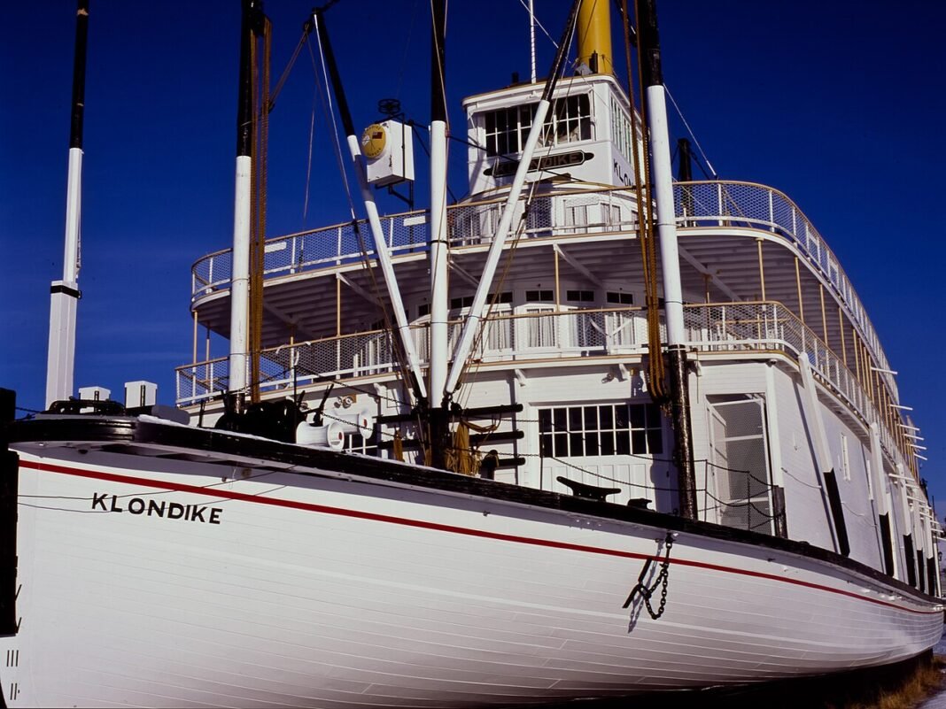
- SS Klondike National Historic Site: The restored sternwheeler SS Klondike on the Yukon River waterfront is the largest sternwheeler ever to ply the Yukon River, a survivor of the era when paddle-wheel steamboats were the primary transport on the river between Whitehorse and Dawson City
- Miles Canyon: The basalt canyon on the Yukon River 3km south of Whitehorse — where the river narrows through 300m of columnar basalt before opening into Schwatka Lake — is the easiest dramatic canyon scenery to reach in the Yukon; the Miles Canyon trail, a loop through boreal forest along both rims, sits a 20-minute drive from downtown
- Fireweed Market and arts: Whitehorse’s arts community — concentrated in the Yukon Arts Centre, the Main Street galleries, and the weekend Fireweed Community Market — reflects the creative energy of a small city with an outsized cultural scene
Dawson City: The Gold Rush Capital
Dawson City (about 1,600 residents, at the confluence of the Yukon and Klondike rivers, 530km north of Whitehorse) is the most historically evocative community in the Canadian north — a preserved Gold Rush boomtown where the wooden false-front buildings of 1898 line unpaved streets, the Parks Canada-administered historic district holds the physical infrastructure of the era when the Klondike drew as many as 30,000 prospectors, and the cultural memory of the stampede survives as lived continuity rather than tourist re-enactment. Dawson City in 2026 carries one of the densest arts communities per capita in the country (the Klondike Institute of Art and Culture, the Berton House writers’ retreat, the Dawson City Music Festival), a summer tourism economy built on gold rush heritage, and a bar culture unlike anywhere else in the Yukon (the Pit and the Downtown Hotel’s famous Sourtoe Cocktail — a drink served with a genuine preserved human toe).
- Dänojà Zho Cultural Centre: The Tr’ondëk Hwëch’in First Nation’s cultural centre in Dawson documents the history and living culture of the people who inhabited this landscape for millennia before the gold rush, providing essential context for understanding the Klondike beyond the prospector narrative
- Bonanza Creek: The richest gold-bearing creek of the entire Klondike (still producing gold today from placer mining operations) runs south of Dawson through the claim-staked hillsides of the goldfields; the Dredge No. 4 National Historic Site — a wooden-hulled gold dredge that worked the creek from 1913 to 1959 — sits in situ at the creek’s edge
- Midnight Dome: The 884m hill above Dawson City delivers the famous view of the Midnight Sun — the Dome is the traditional vantage point for watching the sun circle the northern horizon without setting at the summer solstice
- Dawson City Music Festival: The annual July folk and roots festival, billed as “Canada’s tiny, perfect festival,” has run continuously since 1979 and keeps its grassroots character, drawing visitors who outnumber Dawson’s year-round population several times over

Kluane National Park: Canada’s Greatest Mountain Wilderness
Kluane National Park and Reserve (22,013km², in the southwestern Yukon adjacent to Alaska’s Wrangell-St. Elias National Park) protects the largest non-polar icefields in the world — the St. Elias Mountains’ icefields rival ice-age glaciation in scale and are visible from the Alaska Highway as the Kluane Range’s permanent snow line. Mount Logan (5,959m), Canada‘s highest peak and the second-highest mountain in North America after Denali, rises within Kluane’s boundaries; the park also shelters the largest wild grizzly bear population in Canada along with significant Dall’s sheep, moose, and wolf populations in the boreal and alpine zones flanking the icefields.
- Hike access: The Kluane icefields open up from the Alaska Highway at the Tachal Dhal (Sheep Mountain) visitor centre near Haines Junction; day hikes in the sub-alpine deliver wildlife viewing and icefield views without expedition gear. The Slims River (east) and St. Elias Lake trails carry multi-day backcountry routes
- Flightseeing: Small aircraft tours from Haines Junction or Kluane Lake fly over the icefields, offering the closest look at the St. Elias icescape — a landscape of such scale that many visitors call it the most significant visual experience of their travels
The Dempster Highway and the Arctic Circle
The Dempster Highway — 736km of gravel from Dawson City to Inuvik, NWT — is one of Canada’s great road trips and the only public highway crossing the Arctic Circle in the country. The Yukon section (465km from Dawson to the NWT border) crosses the Ogilvie and Richardson Mountains through landscapes of unusual scale and wildlife density: Dall’s sheep on the mountain ridges, grizzly bears in the river valleys, and the full suite of Yukon wildlife visible from the road in a way impossible on more managed highways. Tombstone Territorial Park (in the first 70km of the Dempster, reached from the Tombstone Mountain Interpretive Centre) holds some of the most arresting terrain in the territory — the Tombstone Range’s jagged granite peaks rising above tundra valleys that turn gold and orange at the late-summer fall colour peak.
Frequently Asked Questions
What is Dawson City and why is it the most historically evocative community in northern Canada?
Dawson City (about 1,600 residents, at the confluence of the Yukon and Klondike rivers, 530km north of Whitehorse) is the preserved gold rush boomtown that anchored the Klondike Gold Rush of 1897–1898, when as many as 30,000 prospectors poured into the region — the last great frontier stampede in North American history. The Parks Canada-administered historic district keeps the wooden false-front buildings of 1898 on unpaved streets; the Palace Grand Theatre, Diamond Tooth Gertie’s gambling hall (Canada’s oldest legal casino), and the Downtown Hotel’s Sourtoe Cocktail (served with a genuine preserved human toe) hold the frontier character with genuine rather than manufactured authenticity. Bonanza Creek, the Klondike’s most productive gold-bearing creek (still producing gold today from placer mining), and the Dredge No. 4 National Historic Site (a wooden-hulled gold dredge from 1913–1959, kept in situ) supply the industrial heritage context. Dawson hosts one of Canada’s most concentrated arts communities per capita.
What is Kluane National Park and what makes it significant?
Kluane National Park and Reserve (22,013km², southwestern Yukon) protects the largest non-polar icefields in the world — the St. Elias Mountains’ icefields rival ice-age glaciation in scale, visible from the Alaska Highway as the Kluane Range’s permanent snow line. Mount Logan (5,959m), Canada’s highest peak and the second-highest mountain in North America after Denali, rises within the park. Kluane forms part of the UNESCO Kluane/Wrangell-St. Elias/Glacier Bay/Tatshenshini-Alsek World Heritage Site — the world’s largest international protected-area complex at some 98,000km² (9.8 million hectares). The park shelters the largest wild grizzly bear population in Canada, along with Dall’s sheep, moose, and wolves. Flightseeing from Haines Junction offers the closest views of the icefields.
What is the Dempster Highway and what does it offer?
The Dempster Highway — 736km of gravel from Dawson City to Inuvik, NWT — is one of North America’s great wilderness road trips and the only public highway crossing the Arctic Circle in Canada. The Yukon section (465km from Dawson to the NWT border) crosses the Ogilvie and Richardson Mountains, with Dall’s sheep on the ridges, grizzly bears in the river valleys, and the full Yukon wildlife spectrum visible from the road. Tombstone Territorial Park (in the first 70km of the Dempster) holds some of the most striking country in the Yukon — the Tombstone Range’s jagged granite peaks above tundra valleys ablaze with fall colour from late August into September. The highway connects to the Inuvik-Tuktoyaktuk Highway (140km), which runs on to the Beaufort Sea — Canada’s only road to the Arctic Ocean.
What is Whitehorse and what does it offer as the Yukon’s capital?
Whitehorse (about 38,000 residents, on the Yukon River in the southern Yukon’s boreal forest) holds roughly three-quarters of the Yukon’s people and ranks consistently among Canada’s most liveable small cities. The Kwanlin Dün Cultural Centre on the Yukon River waterfront — celebrating the First Nation whose territory includes the Whitehorse area — is one of Canada’s finest First Nations cultural facilities, with traditional Southern Tutchone design elements and year-round cultural programming. The SS Klondike National Historic Site keeps the largest sternwheeler ever to ply the Yukon River on the riverfront. Miles Canyon (3km from downtown) delivers basalt canyon scenery on the Yukon River. The Whitehorse area’s trail network puts wilderness cross-country skiing, snowshoeing, and hiking within reach of the city, making it among the most outdoor-oriented capitals in the country.
When is the best time to visit the Yukon and what practical information should visitors know?
The Yukon rewards different visits by season: June–July for the midnight sun (the sun doesn’t set for days around the summer solstice at Dawson City), wildflower meadows, and canoeing the Yukon River. August–September for the fall colour in Tombstone Territorial Park (one of the finest autumn displays in North America — late August to mid-September is optimal) and the return of dark skies for northern lights viewing. February–March for prime aurora borealis season and winter wilderness activities. Whitehorse Erik Nielsen International Airport receives direct flights from Vancouver, Calgary, and Edmonton. The Alaska Highway provides road access from the south. A rental car or campervan is essential for exploring beyond Whitehorse. The Yukon River Quest (June, the world’s longest annual canoe and kayak race, 715km from Whitehorse to Dawson City) is the Yukon’s most extraordinary annual event.