Montana is the fourth-largest state in the United States and one of the least densely populated — a land of such scale that “Big Sky Country” reads less like a marketing slogan than a plain physical description of what happens when the horizon runs to distances that flatten the human sense of proportion. The state’s two great national parks — Glacier in the northwest and the northern reach of Yellowstone in the south — anchor a travel landscape of unusual range: the high alpine terrain of the Rocky Mountain Front, the rolling grass ocean of the Great Plains that begins east of the mountains and runs to the Missouri River Breaks and the badlands of the southeast, the Missouri’s historic canoe route through some of the least-changed country in the American interior, and the small cities of Missoula, Bozeman, and Billings that supply the cultural and culinary infrastructure for exploring the state’s wilderness. This is a place that rewards travelers who come with time — the distances are real, and the landscapes reveal themselves slowly.

Glacier National Park
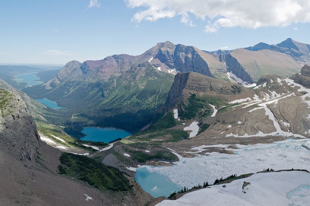
For concentrated alpine scenery in an accessible setting, Glacier has few rivals among the national parks of the lower 48 — 1,583 square miles in the Rocky Mountains of northwestern Montana, hard against the Canadian border, where glacially carved peaks rise straight off the valley floors into cirques, arêtes, and hanging valleys that define the word “alpine.” The Going-to-the-Sun Road, a 50-mile engineering feat that crosses the Continental Divide at Logan Pass (6,646 feet), ranks with the great mountain drives anywhere — a route blasted from the cliffs above Lake McDonald and Saint Mary Lake, threading avalanche country and topping the Divide in a stretch that snow closes for seven to eight months a year and that opens fully only from roughly July to October. In 2026 the park has suspended its timed vehicle-reservation system, so no entry reservation is needed; visitors still need a park pass, and from July 1 parking at Logan Pass is capped at three hours with a new ticketed shuttle serving longer alpine hikes.
The hiking spans every level of effort. The Trail of the Cedars is an easy, wheelchair-accessible boardwalk through ancient cedar and hemlock forest along Avalanche Creek; the Highline Trail is a far stiffer proposition, running 7.6 miles from Logan Pass to the Granite Park Chalet along the Garden Wall on the Continental Divide at 7,000-plus feet, with views down both flanks of the Divide. Quieter still are the backcountry circuits in the remote Two Medicine, Many Glacier, and North Fork areas, which see a fraction of the Logan Pass crowds. Many Glacier is the standout for day hikers — its road reaches the Swiftcurrent Motor Inn and the trailheads for Grinnell Glacier and Iceberg Lake, pairing easy access with scenery that holds its own anywhere in the park. The Grinnell Glacier trail (10.6 miles round trip from the trailhead, or 7.2 miles if you take the boat shuttle across Swiftcurrent Lake and Lake Josephine, with 1,600 feet of climbing) finishes at the surface of one of the park’s 26 remaining named glaciers — a shrinking remnant of the ice that carved this whole landscape, and one the park warns could vanish within a generation as the ice continues to retreat.

Yellowstone’s Montana Gateway
Most of Yellowstone National Park sits in Wyoming, but Montana holds three of its gateways — West Yellowstone, Gardiner, and Cooke City. Gardiner is the historic approach, leading through the Roosevelt Arch (where Teddy Roosevelt laid the cornerstone in 1903) into the Mammoth Hot Springs district, home to the park’s administrative headquarters and the terraced travertine of the Mammoth Springs. The Lamar Valley, reached from the northeast entrance at Cooke City, is the premier wildlife-watching ground in the lower 48 — a broad, ice-gouged valley where bison move in herds of hundreds and the wolves reintroduced in 1995 (now numbering 100-plus in the park) turn up from the road with real regularity. Set up a spotting scope on the ridgeline at dawn or dusk, and few places in the country offer better odds of watching large predators in the wild.
Missoula: Montana’s Cultural Capital
Missoula, set where three rivers meet in western Montana, is the most cosmopolitan of the state’s cities — a university town (home to the University of Montana and its well-regarded creative-writing MFA) whose coffee-shop, brewery, and independent-bookstore culture far outpaces what a population of around 80,000 would suggest. The Clark Fork River runs straight through downtown, and its riverside trail system anchors the rhythm of daily life here. The Rattlesnake National Recreation Area and Wilderness, one of the largest urban wilderness areas anywhere in the US, lies a 20-minute walk from the center — miles of trail through old-growth ponderosa pine and Douglas fir, reachable on foot without a car. The Saturday farmers market, the International Wildlife Film Festival (the oldest of its kind in the world, running since 1977), and the Montana Book Festival all point to a cultural depth out of scale with the city’s size.
Bozeman: The New West’s Hub
Bozeman, about 80 miles north of Yellowstone’s north entrance on I-90, has been one of the fastest-growing cities in the American West — propelled by remote-work migration, the research engine of Montana State University, and a wealth of outdoor access close at hand (Big Sky Resort lies 45 miles south, the Bridger Bowl ski area 16 miles from downtown, and Hyalite Canyon’s year-round recreation just 20 minutes from Main Street). Downtown — the Main Street corridor with its independent restaurants, the Emerson Center for the Arts, the public library’s community programming, and the Saturday farmers market — carries a cultural density that has turned the town into a magnet for the professional and creative classes chasing outdoor access without giving up urban life.
The Missouri River Breaks
The Missouri River Breaks — the 149-mile Wild and Scenic River corridor from Fort Benton to the Fred Robinson Bridge in central Montana — ranks among the least-visited and most historically resonant river stretches in America. Lewis and Clark canoed this section of the Missouri in 1805, and the landscape they recorded (white cliffs of eroded sandstone, cottonwood bottoms, eagle nests, bighorn sheep on the canyon walls) is essentially unchanged from their journals. A float trip through the Breaks — typically five to seven days by canoe or kayak out of Fort Benton — is the fullest Lewis and Clark immersion still on offer and a wilderness river journey with few peers, a passage through terrain where you camp in the cottonwood bottoms and look up at canyon walls that no road crosses for 150 miles.
Frequently Asked Questions
What is the Going-to-the-Sun Road in Glacier National Park?
The Going-to-the-Sun Road is a 50-mile engineering feat that crosses the Continental Divide at Logan Pass (6,646 feet) in Glacier National Park, ranking among the great mountain drives anywhere. Blasted from the cliffs above Lake McDonald and Saint Mary Lake and threading avalanche country before topping the Divide, the road is closed by snow for seven to eight months a year and fully open only from roughly July to October. Glacier National Park covers 1,583 square miles in northwestern Montana on the US-Canada border, where glacially carved peaks rise straight off the valley floors into cirques, arêtes, and hanging valleys. The park’s 26 remaining named glaciers (down from an estimated 150 when the park was established in 1910) are all shrinking, and the park no longer fixes a single disappearance date, noting only that when they will be gone is uncertain. Glacier is also a UNESCO World Heritage Site, designated in 1995 together with Canada’s Waterton Lakes National Park as the Waterton-Glacier International Peace Park. Note that for 2026 the park has suspended its timed vehicle-reservation system, though a park pass is still required.
What are the best hikes in Glacier National Park?
Glacier offers strong hiking at every level. The Trail of the Cedars is a wheelchair-accessible boardwalk through ancient cedar and hemlock forest along Avalanche Creek. The Highline Trail (7.6 miles one-way from Logan Pass to the Granite Park Chalet) traverses the Garden Wall along the Continental Divide at 7,000-plus feet, with views down both sides of the Divide. In the Many Glacier area, the Grinnell Glacier Trail (10.6 miles round trip, or 7.2 miles with the boat shuttle across Swiftcurrent Lake and Lake Josephine, 1,600 feet of elevation gain) ends at the surface of one of the park’s remaining glaciers — a shrinking remnant of the ice that carved the entire park. The Iceberg Lake Trail from Many Glacier delivers spectacular alpine scenery at lower difficulty. The remote Two Medicine, Many Glacier, and North Fork areas see a fraction of the Logan Pass crowds.
What wildlife can you see in Glacier and Yellowstone from Montana?
The Lamar Valley in Yellowstone — reached from the northeast entrance at Cooke City, Montana — is the premier wildlife-watching ground in the lower 48. In this broad, ice-gouged valley, bison move in herds of hundreds and the wolves reintroduced in 1995 (now numbering 100-plus in the park) turn up from the road with real regularity. A spotting scope trained on the ridgelines at dawn and dusk gives you about the best odds in the country of watching large predators in the wild. Montana’s northern Yellowstone gateway runs through Gardiner, via the Roosevelt Arch (where Teddy Roosevelt laid the cornerstone in 1903) into the Mammoth Hot Springs district — the park’s administrative headquarters and the site of its terraced travertine formations. In Glacier National Park, grizzly bears, mountain goats, and bighorn sheep are regularly sighted along the Going-to-the-Sun Road corridor.
What makes Missoula and Bozeman worth visiting in Montana?
Missoula, set where three rivers meet in western Montana, is the most cosmopolitan of the state’s cities — a University of Montana college town of around 80,000 whose coffee shops, breweries, and independent bookstores far outpace its size. The Rattlesnake National Recreation Area and Wilderness — one of the largest urban wilderness areas in the US — lies a 20-minute walk from downtown. The Clark Fork River runs straight through town and shapes the rhythm of daily life. Bozeman, about 80 miles north of Yellowstone’s north entrance, is among the fastest-growing small cities in the American West, driven by remote-work migration and outdoor access: Big Sky Resort is 45 miles south, the Bridger Bowl ski area 16 miles from downtown, and Hyalite Canyon 20 minutes from Main Street.
What is the Missouri River Breaks and why is it historically significant?
The Missouri River Breaks — the 149-mile Wild and Scenic River corridor from Fort Benton to the Fred Robinson Bridge in central Montana — ranks among the least-visited and most historically resonant river stretches in America. Lewis and Clark canoed this section of the Missouri in 1805, and the landscape they recorded — white cliffs of eroded sandstone, cottonwood bottoms, eagle nests, bighorn sheep on canyon walls — is essentially unchanged from their journals. A float trip through the Breaks (typically five to seven days by canoe or kayak from Fort Benton) is the fullest Lewis and Clark immersion still on offer and one of the finest wilderness river journeys in the country. No road crosses the canyon walls for 150 miles, and camping in the cottonwood bottoms ranks among the most secluded wilderness experiences in the American interior.