Illinois carries a geographic contradiction: the state most associated with flat farmland holds some of the Midwest’s most varied natural country. The 26 miles of Chicago’s lakefront parks — a continuous greenway running from Hollywood Avenue on the north to South Shore on the south — amount to one of the finest urban outdoor environments in any American city. Far to the south, the sandstone formations and forest canyons of Shawnee National Forest feel closer to the Ozarks than to anything the Midwest stereotype suggests. Between those two poles, Illinois’s rivers, state parks, and prairie preserves repay any resident or visitor willing to look past the cornfields rolling by on I-55 and I-57.

Chicago Lakefront: Urban Outdoor Excellence
The Chicago Lakefront Trail is the busiest shared-use trail in the United States — an 18-mile pathway along Lake Michigan that touches every lakefront park, beach, harbor, and cultural institution between Hollywood Avenue and 71st Street. On summer weekends the trail draws tens of thousands of cyclists, runners, rollerbladers, and walkers sharing what amounts to a linear park of rare urban quality. The reconstruction near Navy Pier and the Riverwalk extension have sharpened connectivity in recent years, and the city’s continued investment in the lakefront reflects how central the trail has become to daily life downtown.
.jpg?width=1200)
Chicago’s beaches — the 26 official Chicago Park District beaches from Juneway Terrace on the far north to 63rd Street Beach on the south — open for staffed swimming from Memorial Day weekend through Labor Day, with lifeguards on duty during posted hours. Montrose Beach, at the northern end of Montrose Harbor, offers the best mix of swimming, kite-flying, dog beach access, and restored natural habitat. North Avenue Beach, in the heart of the Lincoln Park lakefront, is the busiest and most built-up, with volleyball courts, rentals, and a beach-house restaurant. The beaches are free and open to all — one of Chicago’s most egalitarian public resources.
Shawnee National Forest: The Illinois Surprise
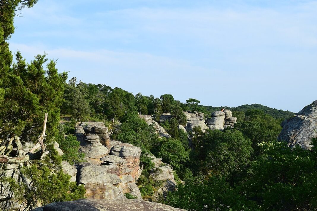
Shawnee National Forest, tucked into southernmost Illinois between the Ohio and Mississippi Rivers, covers roughly 289,000 acres of forested hills, sandstone canyons, natural arches, cypress swamps, and rock formations found nowhere else in the state. The terrain — shaped by hundreds of millions of years of geology that left sandstone deposits, river bluffs, and the remnants of ancient seas — bears no resemblance to the glaciated flatlands of northern and central Illinois.

The Garden of the Gods Wilderness — a 3,300-acre designated wilderness within Shawnee — holds the forest’s most dramatic formations. The Observation Trail (0.25 miles) reaches the main sandstone towers, Camel Rock and Anvil Rock among them, with almost no effort, while the longer Buzzard Point Loop (4 miles) opens up ridge hiking and views across the Saline River valley. Burden Falls, reached by a short trail near Eddyville, drops over a sheer sandstone ledge and tumbles through a series of cascades — at roughly 100 feet of total fall, it is the tallest waterfall in Illinois, and it surprises visitors who expected nothing but flat farmland this far south.
The Bell Smith Springs area, near the center of Shawnee, packs in the forest’s most varied short hiking: natural bridges, canyon pools, stream crossings, and the Beaver Pond loop through bottomland forest that shelters migratory waterfowl and resident great blue herons. Spring wildflower season (mid-April through May) brings out trillium, mayapple, bloodroot, and wild ginger across the forest understory — which is why spring is the prime window for Shawnee hiking.
Illinois State Parks: Best Options
Starved Rock State Park, 90 miles southwest of Chicago in LaSalle County, is the most visited state park in Illinois — a run of 18 canyons carved by post-glacial meltwater into St. Peter Sandstone bedrock, with waterfalls at their best in spring and after rain and canyon hiking along the Illinois River bluffs, all within easy reach of the city. The trails range from accessible boardwalk paths to canyon-floor routes that require stream crossings; St. Louis Canyon and Wildcat Canyon are the standout destinations on the system.

Matthiessen State Park, next door to Starved Rock, offers much the same canyon geology with far fewer people — a good choice for anyone put off by Starved Rock’s summer crowds. The Dells area of Matthiessen, with its tiered travertine falls and sandstone canyon walls, ranks among the most photogenic natural settings in northern Illinois.
Giant City State Park in southern Illinois, near Carbondale, lays out “streets” of sandstone bluffs — the natural rock formations that give the park its name — alongside access to Little Grassy Lake, with hiking, equestrian trails, and rappelling in a landscape geologically distinct from the Shawnee formations to the east.
Cycling: Prairie Trails and the Great River Road
Illinois’s flat terrain and deep network of rail-trail conversions give it one of the strongest cycling networks in the region. The Illinois & Michigan Canal State Trail follows the historic towpath for about 61 miles from Rockdale, near Joliet, down to LaSalle — a gravel route through a corridor that once linked Chicago to the Illinois River valley and now connects Channahon, Morris, and Utica near Starved Rock. The Great River Road, which runs the length of the Illinois side of the Mississippi from the Galena area south toward Cairo — carried by Illinois Route 84 along its scenic northwestern stretch — traces one of the continent’s great rivers past river-bottom farmland, limestone bluffs, and historic river towns that reward multi-day touring. The Hennepin Canal Parkway State Park runs 104 miles of waterside trail along the old canal — flat the whole way, shaded by mature trees, and largely free of motor-vehicle conflict.
Birding: One of the Midwest’s Best
Illinois sits where the Central and Mississippi flyways converge, which puts it among the most productive birding states in the Midwest during spring and fall migration. Montrose Point Bird Sanctuary in Chicago — a 15-acre naturalized peninsula reaching into Lake Michigan that funnels migrating songbirds each spring — ranks among the great migration hotspots of the eastern United States. The Magic Hedge, a dense shrub planting on the point, pulls in warblers, vireos, and flycatchers in remarkable numbers at the May migration peak. Farther downstate, Chautauqua National Wildlife Refuge near Havana, on the Illinois River in Mason County, draws tens of thousands of waterfowl and migrating cranes to its managed wetlands each fall, when the floodplain fills with birds staging before they push south.
Illinois’s outdoor country is more substantial than its flat-state reputation lets on. The lakefront, the canyons, the forests, and the rivers together keep Illinois residents outdoors across all four seasons — winter included, when cross-country skiing at Matthiessen and Starved Rock, ice fishing on the inland lakes, and the stark beauty of the frozen lakefront offer something specific to the northern Illinois winter that first-time residents dread and, given a winter or two, come to appreciate.
Frequently Asked Questions
What outdoor activities does Chicago’s lakefront offer?
The Chicago Lakefront Trail is the busiest shared-use trail in the United States — an 18-mile pathway along Lake Michigan passing every lakefront park, beach, harbor, and cultural institution between Hollywood Avenue and 71st Street, drawing tens of thousands of users on summer weekends. The 26 official Chicago Park District beaches open for staffed swimming from Memorial Day through Labor Day; Montrose Beach offers the finest mix of swimming, restored habitat, and dog beach access. North Avenue Beach, in Lincoln Park, is the most developed lakefront recreation area, with volleyball courts and rentals. The lakefront is entirely free and ranks among the most democratic urban outdoor amenities in any American city.
What is Shawnee National Forest and what makes it different from typical Illinois landscape?
Shawnee National Forest, in southernmost Illinois between the Ohio and Mississippi Rivers, covers roughly 289,000 acres of sandstone canyons, natural arches, forest, and cypress swamps with no parallel elsewhere in the state. The Garden of the Gods Wilderness — a 3,300-acre designated wilderness — holds the most dramatic sandstone formations in Illinois; the Observation Trail (0.25 miles) reaches Camel Rock and Anvil Rock with minimal effort, while the Buzzard Point Loop (4 miles) opens up ridge hiking and views across the Saline River valley. The Bell Smith Springs area adds natural bridges, canyon pools, and stream crossings. Spring wildflower season (mid-April through May) brings trillium, mayapple, and bloodroot displays — making Shawnee one of the Midwest’s finest spring wildflower destinations.
What does Starved Rock State Park offer?
Starved Rock State Park, 90 miles southwest of Chicago in LaSalle County, is the most visited state park in Illinois — 18 canyons carved by post-glacial meltwater into St. Peter Sandstone bedrock, with waterfalls (best in spring and after rain) and canyon hiking along the Illinois River bluffs. St. Louis Canyon and Wildcat Canyon are the standout trail destinations. Matthiessen State Park, next door, offers similar sandstone canyon geology with far fewer visitors — its Dells area, with tiered travertine falls and sandstone walls, ranks among the most photogenic natural settings in northern Illinois. Both parks work as day trips from Chicago and together provide the most rewarding canyon hiking in the Midwest within two hours of a major city.
What cycling opportunities does Illinois offer?
Illinois’s flat terrain and extensive rail-trail network rank it among the strongest cycling states in the region. The Illinois & Michigan Canal State Trail follows about 61 miles of the historic towpath from Rockdale, near Joliet, down to LaSalle — a gravel route through the canal corridor and Illinois River valley, passing Channahon, Morris, and Utica near Starved Rock. The Hennepin Canal Parkway State Park runs 104 miles of waterside trail along the old canal, flat and shaded and free of motor-vehicle conflict. The Great River Road, carried by Illinois Route 84 along the Mississippi in its northern reach from the Galena area toward Cairo, follows one of the continent’s great rivers past limestone bluffs and historic river towns — well suited to multi-day bicycle touring.
What makes Illinois one of the Midwest’s best birding states?
Illinois sits where the Central and Mississippi flyways converge, which puts it among the most productive birding states in the Midwest during spring and fall migration. Montrose Point Bird Sanctuary in Chicago — a 15-acre naturalized peninsula reaching into Lake Michigan — is one of the most celebrated migration hotspots in the eastern United States; the Magic Hedge pulls in remarkable concentrations of warblers, vireos, and flycatchers at the May migration peak. Chautauqua National Wildlife Refuge near Havana, on the Illinois River in Mason County, draws tens of thousands of waterfowl and migrating cranes to its managed wetlands each fall. Shawnee’s bottomland forests and the Mississippi River bottoms in far western Illinois add exceptional waterfowl and neotropical migrant viewing in spring.