Few states pack as much landscape into their borders as New Mexico. The gypsum desert of White Sands, the alpine peaks of the Sangre de Cristo and Jemez Mountains, the ancient lava fields of El Malpais, the river canyon of the Rio Grande Gorge, the cave systems of the Guadalupe Mountains, and the wilderness of the Gila National Forest add up to an outdoor range as broad as anywhere in the American West. More than 300 days of sunshine a year keep that range open in every season, and the altitude spread does the rest: from the Chihuahuan Desert floor near 3,500 feet to the 13,167-foot summit of Wheeler Peak, the state’s highest point, desert hikers and alpine climbers find their terrain within a short drive of any major New Mexico city.

White Sands: Desert Hiking and Sledding
White Sands National Park protects 275 square miles of gypsum dune field, a hiking environment that exists nowhere else in North America. The Alkali Flat Trail (4.6 miles round trip) pushes into the heart of the dunes toward the remnant flat of ancient Lake Otero, crossing the most pristine and remote stretch of the park, where the Sacramento and San Andres Mountains ring a white horizon that looks like no conventional landscape. Wooden posts mark the way, since the migrating dunes bury ordinary trail markers within days, and following them across blank sand is a real orientation challenge. Shorter walks cover the same ecology in less time: the Dune Life Nature Trail runs one mile, and the Playa Trail covers half a mile.
Heat dictates everything here. From May through September, temperatures top 100°F regularly, and the white sand bounces solar radiation back at hikers in a way darker desert surfaces never do, so the recommended summer minimum runs to a full liter of water per person per hour of activity — far more than most visitors expect to carry. Backcountry camping (permits required, limited sites) puts you in the dune field for the sunrise and sunset hours when day-trip traffic has cleared. To trace the geology back to its source, the Interdune Boardwalk and the reservation-only Lake Lucero tour reach the selenite crystal lake bed where the gypsum itself begins.
The Gila Wilderness and National Forest
Spread across 3.3 million acres of mountains and canyons in southwestern New Mexico, the Gila National Forest holds the Gila Wilderness, the first designated wilderness area in the United States. Aldo Leopold, the Forest Service official who shaped his land-ethic philosophy in this country, secured its protection in 1924. The Gila River splits into three forks — West, Middle, and East — and each carves canyon-hiking routes through basalt and limestone narrows where the water has to be crossed dozens of times on any long outing. Those walls shelter a remarkable concentration of wildlife: black bears, mountain lions, Mexican gray wolves (reintroduced since 1998), Gila trout (a federally threatened species found in only a handful of New Mexico streams), and enough desert and riparian birdlife to rank the Gila among the top birding destinations in the Southwest.
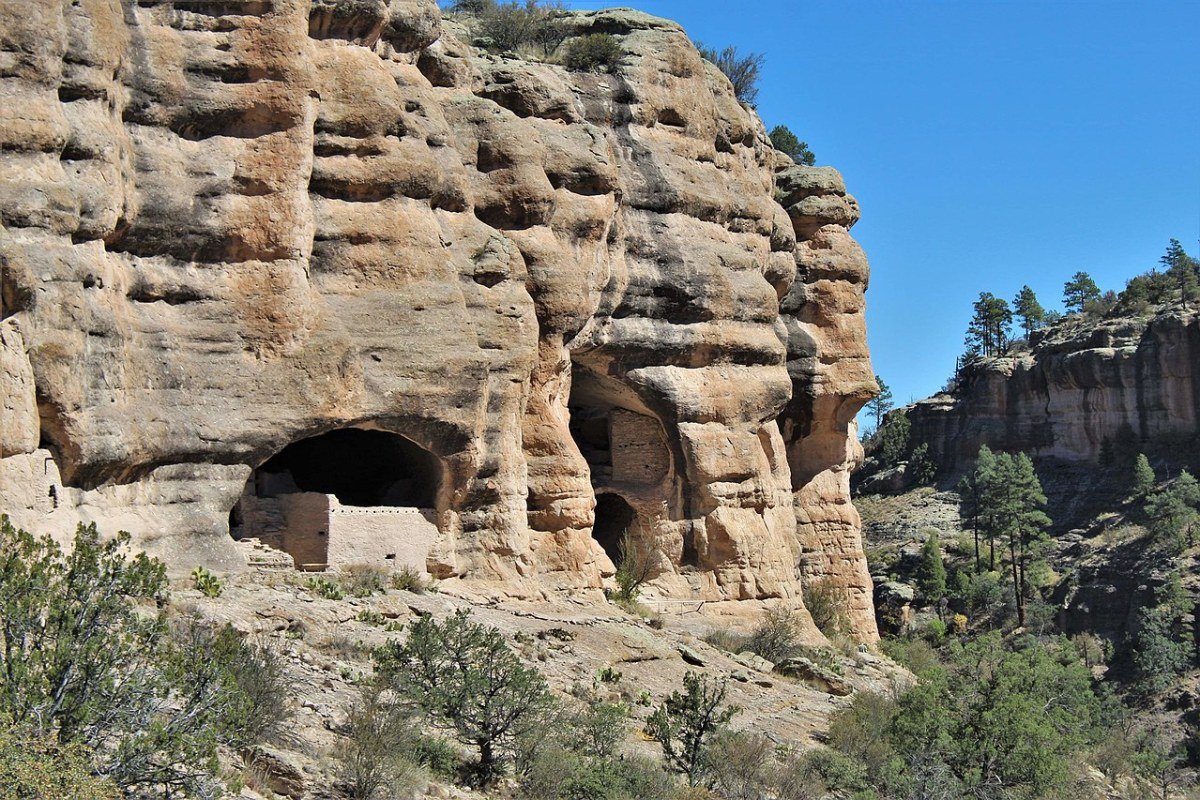
Tucked into the same forest, the Gila Cliff Dwellings National Monument preserves homes the Mogollon people built roughly 700 years ago in natural cave alcoves above the West Fork. A one-mile trail from the visitor center leads up into the dwellings themselves, 42 rooms set into the rock face, and the encounter is closer and far less crowded than the famous cliff dwellings of Mesa Verde. Deeper in, the hot springs along the Middle Fork sit at the end of a multi-mile approach on foot, and that walk-in barrier keeps the geothermal pools quiet even at the height of the season.
Sangre de Cristo Mountains: Hiking and Skiing
Rising straight out of the desert east of Santa Fe and Taos to elevations above 13,000 feet, the Sangre de Cristo Mountains hold the most accessible alpine hiking and skiing in northern New Mexico. Wheeler Peak (13,167 feet, the state’s highest point) draws climbers along two main routes from Taos Ski Valley: the Williams Lake Trail (about 8 miles round trip, with roughly 3,000 feet of gain), which climbs past the tarn beneath Wheeler’s north face, and the longer Bull-of-the-Woods route that follows the high ridgeline to the summit. At the crest above town, Ski Santa Fe drops its runs from 12,075 feet to a 10,350-foot base, genuinely high-altitude skiing even if the resort’s modest footprint (87 runs, 660 acres) keeps the terrain variety in check. Taos Ski Valley, the state’s premier resort, spreads 110 runs across 1,294 acres with a 2,612-foot vertical drop and a reputation for some of the most challenging terrain in the Southwest.
North of there, above Pecos and inside the Santa Fe National Forest, the Pecos Wilderness opens 223,000 acres of designated backcountry: 14 peaks above 12,000 feet, alpine lakes, and the headwaters of the Pecos River, one of the finest native trout fisheries in the state. The Truchas Peak circuit (roughly 20 miles, wilderness camping permits required) is the most demanding and most rewarding multi-day route in northern New Mexico, tracing the high ridgeline between the three Truchas Peaks, the tallest at 13,102 feet, with views west across the Rio Grande valley to the Jemez Mountains.
Rio Grande and the Jemez Mountains

The Rio Grande Gorge opens almost without warning in the flat volcanic plain, the river dropping 800 feet through the Taos Plateau basalt. It delivers both whitewater and canyon hiking. On the water, the Taos Box — the 17-mile run from the Arroyo Hondo confluence down to Pilar — is the best whitewater in New Mexico, Class III–IV at normal spring flows. On foot, the Rio Grande del Norte National Monument protects the gorge and surrounding plateau, with trails along the rim and routes down to the river itself. Spring snowmelt in April and May brings the biggest flows and the hardest conditions; summer monsoon rains can swing river levels and clarity through July and August.
West of Los Alamos, the Jemez Mountains offer the opposite kind of country: an eroded volcanic caldera ringed by ponderosa pine and mixed conifer. At its center sits the Valles Caldera National Preserve, a 13-mile-wide collapsed crater of open meadow, and along the Jemez River the natural pools at Jemez Springs draw soakers to the warm water. Above Frijoles Canyon, Bandelier National Monument preserves the homes the Ancestral Pueblo people carved into soft volcanic tuff between 1150 and 1550 CE. The Jemez Mountain Trail Scenic Byway (NM Route 4) strings the caldera, Bandelier, and the historic Jemez Pueblo into a single loop, about as complete a geological, ecological, and cultural tour as you can manage in a day’s drive from Albuquerque or Santa Fe.
Frequently Asked Questions
What does White Sands National Park offer for outdoor recreation?
White Sands National Park’s 275 square miles of gypsum dune field offer hiking experiences available nowhere else in North America. The Alkali Flat Trail (4.6 miles round trip) ventures into the heart of the dune field to the remnant flat of ancient Lake Otero — navigation is by wooden posts, as conventional trail markers are quickly buried by migrating dunes, creating a genuine orientation challenge. The park’s backcountry camping program (permits required, limited sites) allows overnight stays in the dune field for sunrise and sunset experiences when visitor traffic is absent. The Interdune Boardwalk and Lake Lucero tour (by reservation) provide access to the selenite crystal lake bed where the gypsum originates. Summer hiking (May–September) requires one liter of water per person per hour due to extreme heat and solar reflection.
What is the Gila Wilderness and what makes it historically significant?
The Gila National Forest (3.3 million acres, southwestern New Mexico) contains the Gila Wilderness — the first designated wilderness area in the United States, designated in 1924 at the urging of Aldo Leopold, the Forest Service official who developed his foundational land ethic philosophy here. The Gila River’s three forks (West, Middle, and East) provide canyon hiking through basalt and limestone narrows requiring dozens of river crossings, through habitat supporting black bears, mountain lions, Mexican gray wolves (reintroduced since 1998), Gila trout (a federally threatened species found only in a handful of New Mexico streams), and exceptional riparian bird diversity. The Gila Cliff Dwellings National Monument within the forest preserves Mogollon people cliff dwellings from approximately 700 years ago — less visited and more intimate than Mesa Verde. Hot springs along the Middle Fork provide geothermal soaking accessible only by wilderness hiking.
What hiking and skiing do the Sangre de Cristo Mountains offer?
The Sangre de Cristo Mountains, rising east of Santa Fe and Taos to above 13,000 feet, provide the most accessible alpine hiking and skiing in northern New Mexico. Wheeler Peak (13,167 feet, New Mexico’s highest point) is accessible via the Williams Lake Trail (about 8 miles round trip, roughly 3,000 feet of gain from Taos Ski Valley) or the longer Bull-of-the-Woods route along the high ridgeline. Taos Ski Valley — New Mexico’s premier resort — offers 110 runs across 1,294 acres with a 2,612-foot vertical drop and terrain among the most challenging in the Southwest. The Pecos Wilderness (223,000 acres, 14 peaks above 12,000 feet) provides the finest native trout fishing in New Mexico on the headwaters of the Pecos River; the Truchas Peak circuit (approximately 20 miles) is the most demanding multi-day route in northern New Mexico.
What does the Rio Grande Gorge offer?
The Rio Grande Gorge, where the river cuts 800 feet through the Taos Plateau volcanic basalt, provides both challenging whitewater and dramatic canyon hiking. The Taos Box — the 17-mile stretch from the Arroyo Hondo confluence to Pilar — is the finest whitewater run in New Mexico, rated Class III–IV in normal spring flows, with commercial rafting operators based in Taos. The Rio Grande del Norte National Monument protects the gorge and volcanic plateau, with hiking trails along the rim and canyon-bottom access to the river. The Orilla Verde Recreation Area at Pilar provides the most accessible riverside camping and flat-water kayaking below the whitewater sections.
What does the Jemez Mountains area offer and how does it connect to the Valles Caldera?
The Jemez Mountains west of Los Alamos provide a contrasting volcanic landscape to the Sangre de Cristos. The Valles Caldera National Preserve — a 13-mile-diameter collapsed volcanic crater, one of the largest calderas in North America — offers hiking, cycling, and fishing in a spectacular open meadow and forested setting accessible by permit reservation. Bandelier National Monument protects cliff dwellings carved into volcanic tuff by Ancestral Pueblo people between 1150 and 1550 CE in Frijoles Canyon — more accessible and less crowded than Mesa Verde. Jemez Springs’ natural hot springs along the Jemez River provide geothermal soaking. The Jemez Mountain Trail Scenic Byway (NM Route 4) connects all three destinations — Valles Caldera, Bandelier, and Jemez Pueblo — in a single-day loop from Albuquerque or Santa Fe.