
Arizona: Where the Earth’s History Is Written in Stone
Arizona is one of those rare places where the landscape itself becomes the primary attraction. The state contains more national monuments than any other in the country, three national parks, and a geological range that runs from the pine-covered peaks of the White Mountains to the saguaro-studded lowland deserts of the Sonoran basin. The Grand Canyon alone — a mile-deep gash in the earth exposing two billion years of geological history — would be enough to anchor any travel itinerary. But Arizona’s depth of experience reaches well beyond its most famous attraction, and travelers who look past the canyon find a state of surprising complexity, cultural richness, and natural beauty.
Arizona draws around 45 million visitors a year, yet most see only a fraction of what the state offers. This guide goes deeper: the parks and landmarks that reward real exploration, the cultural layers that make Arizona historically and artistically compelling, and the practical realities of visiting a place where temperatures at different elevations can swing by 50 degrees on the same afternoon.

Grand Canyon National Park: Beyond the Overlook
The Grand Canyon runs 277 river miles long, up to 18 miles wide, and more than a mile deep. It is the largest canyon in the United States and, by almost any measure, the most visually overwhelming scenery the country has to offer. The rim-to-rim distance is 10 miles as the crow flies but 21 miles on foot via the corridor trails — a reminder that the canyon’s apparent simplicity hides remarkable physical complexity.

Most visitors see the South Rim, which is open year-round and reachable by car. This is the right choice for first-timers: the rim trail delivers continuous canyon views, the geology overlooks are well-interpreted, and the combination of Mather Point, Yavapai Geology Museum, and Desert View Watchtower covers the canyon’s visual and scientific highlights effectively. The South Rim at peak season (June–August) gets seriously crowded, though, and standing at a world-famous overlook hemmed in by hundreds of other tourists feels worlds apart from the canyon’s more demanding interior.
The North Rim — open mid-May through mid-October only, thanks to winter snowpack — remains the superior experience for travelers willing to drive the extra 215 miles from the South Rim. It sits 1,000 feet higher, receives less than a tenth of the South Rim’s visitors, and gives a strikingly different perspective on the canyon from the Bright Angel Point and Cape Royal viewpoints. The picture changed materially in 2025: the Dragon Bravo Fire, ignited by lightning on July 4, swept through the developed area on the night of July 13 and destroyed the historic Grand Canyon Lodge along with more than a hundred other structures. For the 2026 season the North Rim reopened to day-use on May 15, with paved roads to Bright Angel Point, Cape Royal, and Point Imperial accessible and the campground operating from June 1 — but with no in-park lodging, no restaurant, and no replacement for the lodge announced. Travelers planning a North Rim visit now need to base out of Kanab, Jacob Lake, or the campground itself.

Hiking into the canyon changes the experience entirely. The Bright Angel Trail — 9.5 miles one way to the Colorado River, descending 4,460 vertical feet — is the most popular inner-canyon route and provides shaded rest stops with water in summer. The South Kaibab Trail is steeper, more exposed, and rewards the effort with sweeping ridge-line views. Day hikers should be realistic: the canyon’s difficulty is routinely underestimated, and the National Park Service’s standing advice is to never attempt rim-to-river-and-back in a single day in warm weather. Backpackers who plan ahead (permits required, often months out) and camp at Bright Angel or Cottonwood campgrounds meet the canyon in a wholly different register — darkness, silence, and a scale of sky the rim never quite delivers.
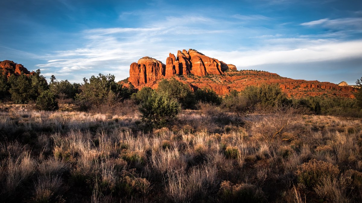
Sedona: Red Rocks, Spirituality, and Superb Hiking
Sedona sits two hours south of the Grand Canyon and 90 minutes north of Phoenix, in a landscape of sculpted red sandstone that ranks among the most camera-ready in Arizona. Cathedral Rock, Bell Rock, Courthouse Butte, and the Boynton Canyon formations rise from high desert terrain in shapes that seem almost deliberately theatrical — and late-afternoon light on red stone, dark green juniper, and a blue-sky backdrop produces color contrasts of rare intensity.
Sedona’s reputation for “vortex” energy centers and New Age spirituality is real and commercially significant — the town has more crystal shops, astrology consultants, and energy healers per capita than perhaps anywhere else in the country — but travelers who engage with that side of Sedona selectively will still find its natural setting more than enough to justify a visit, whatever their metaphysical leanings. The hiking is first-rate: trails like Devil’s Bridge (a sweeping natural sandstone arch), Cathedral Rock (a steep scramble with commanding views), and Bear Mountain (strenuous but rewarding) pair accessible terrain with spectacular scenery.
Monument Valley: The American West Distilled
Monument Valley Navajo Tribal Park straddles the Arizona-Utah border and holds the most recognizable scenery in the American West — arguably in the entire world. The sandstone buttes known as the Mittens and Merrick Butte have appeared in hundreds of films, advertisements, and photographs, and their silhouettes have become shorthand for a certain idea of the American frontier. Standing before them in person, especially at dawn or dusk when the light turns the stone a deep, saturated red, carries a visual power that justifies every cliché.

The park is Navajo Nation land, and the 17-mile unpaved Valley Drive is the primary access route. Most of the interior is restricted to Navajo-guided tours, which earn their keep: guides share the history, geology, and personal connection to a place that has been the home of the Diné people for centuries. Navajo-owned operators run jeep tours, horseback rides, and photography expeditions. The View Hotel — the only accommodation inside the park boundary — opens onto unobstructed butte views from its rooms and restaurant terrace, and dawn light on the formations from this vantage point is one of the finest photographic opportunities in the Southwest.
Antelope Canyon and Lake Powell
Antelope Canyon, near Page in the far north of Arizona, is the most visited slot canyon in the American Southwest and one of the most heavily photographed spots on Earth. The canyon — actually two separate canyons, Upper Antelope (The Crack) and Lower Antelope (The Corkscrew) — was carved by flash floods through Navajo sandstone over millennia, leaving sinuous, wave-like walls that funnel and scatter light into intricate patterns. Between roughly 11am and 1pm, shafts of direct sunlight pour through the narrow openings and form columns of light that have become signature photographic subjects.
Like Monument Valley, Antelope Canyon is on Navajo Nation land and requires a guided tour booked through licensed Navajo operators. Tours sell out weeks ahead for peak season visits (March–October). Lake Powell, adjacent to Page, offers a completely different Arizona experience: a reservoir created by Glen Canyon Dam that reaches 186 miles into the surrounding canyon country, forming a maze of red-rock inlets, coves, and beaches reachable by houseboat, kayak, or motorboat.
Saguaro National Park and the Sonoran Desert
Saguaro National Park, split into two districts flanking Tucson, protects the signature scenery of the Sonoran Desert — the dense forest of saguaro cacti that grows only in this corner of the world. The saguaro is the largest cactus species in the United States, capable of reaching 40 feet in height and living 150–200 years. A mature saguaro with multiple arms represents decades of slow growth in an environment that tests every organism living within it.

The park is at its best in spring (February–April), when wildflowers bloom across the desert floor and saguaros open creamy white flowers at the tips of their arms. The West District’s Bajada Loop Drive gives an accessible overview of the desert; the East District’s Rincon Mountain trails climb into a different ecosystem entirely, shifting from desert to woodland to coniferous forest as the elevation rises. Pairing the two districts in a single Tucson visit makes for a compelling cross-section of what the Sonoran Desert holds at varying elevations.
Flagstaff and the High Country
At 7,000 feet elevation, Flagstaff is Arizona’s high-country hub — a university city with a genuine downtown, excellent restaurants, superb dark-sky stargazing, and access to a landscape utterly unlike the desert zones most people picture when they think of the state. The San Francisco Peaks climb to over 12,600 feet north of town; Humphreys Peak, the highest point in Arizona, makes for a challenging but attainable summit hike for fit walkers. The Arizona Snowbowl ski area operates on the Peaks in winter.
Flagstaff’s position on Route 66 and its role as gateway to the Grand Canyon lend it real historic character — the Weatherford Hotel, built in 1900, and the Hotel Monte Vista, which hosted everyone from Bing Crosby to Humphrey Bogart during Hollywood’s golden era, still operate in the historic downtown. The Museum of Northern Arizona, a world-class institution devoted to the natural and cultural history of the Colorado Plateau, justifies a half-day for anyone drawn to the region’s deep archaeological heritage.
Practical Travel Information
Best time to visit: Phoenix and the low desert are ideal October–April; summer temperatures routinely top 110°F and midday outdoor activity turns flat-out dangerous. Sedona and Flagstaff stay more moderate and reward a visit year-round. The Grand Canyon’s South Rim is open all year; the North Rim closes in winter.
Getting around: A rental car is essential for any meaningful Arizona itinerary. The state’s major attractions are spread across vast distances — Phoenix to the Grand Canyon is 4 hours, Phoenix to Monument Valley is 5.5 hours — and public transportation between destinations is extremely limited.
Altitude awareness: The elevation gap between Phoenix (1,100 feet) and Flagstaff (7,000 feet) or the Grand Canyon North Rim (8,200 feet) is large enough to trigger altitude-related symptoms in some visitors, particularly those arriving from sea level. Allow a day to acclimate before strenuous hiking at elevation.
Frequently Asked Questions
How do you make the most of a Grand Canyon visit?
The Grand Canyon runs 277 river miles long, up to 18 miles wide, and more than a mile deep — the largest canyon in the United States and one of the most overwhelming sights in the country. Most visitors see the South Rim, which is open year-round and the right choice for first-timers; the rim trail delivers continuous views, and the combination of Mather Point, Yavapai Geology Museum, and Desert View Watchtower covers the highlights effectively. The North Rim — open mid-May through mid-October only — sits 1,000 feet higher than the South Rim, receives less than a tenth of its visitors, and gives a strikingly different perspective from Bright Angel Point and Cape Royal. It requires driving an extra 215 miles but rewards with far fewer crowds; the historic Grand Canyon Lodge was destroyed by the Dragon Bravo Fire in July 2025, and the 2026 season is day-use only — paved roads to Bright Angel Point, Cape Royal, and Point Imperial reopened May 15, the campground June 1, but no in-park lodging is available. Hiking into the canyon transforms the visit: the Bright Angel Trail (9.5 miles one way to the Colorado River, descending 4,460 vertical feet) is the most popular inner-canyon route. Backpackers with permits (often required months in advance) who camp at Bright Angel Campground meet the canyon in a wholly different register.
What makes Sedona one of Arizona’s most compelling destinations?
Sedona sits two hours south of the Grand Canyon in a landscape of sculpted red sandstone that ranks among the most photographed in Arizona. Cathedral Rock, Bell Rock, Courthouse Butte, and the Boynton Canyon formations rise from high desert terrain in shapes that produce rare color contrasts of red stone, dark green juniper, and blue sky. The hiking is genuinely excellent: Devil’s Bridge (a sweeping natural sandstone arch), Cathedral Rock (a steep scramble with commanding views), and Bear Mountain (strenuous but rewarding) pair accessible terrain with spectacular scenery. The Sedona area is also Arizona’s premier mountain biking destination, with internationally recognized trail networks including the Bell Rock Pathway, Llama Trail, and the more technical Hiline Trail. Sedona’s New Age vortex reputation is commercially significant, but the natural setting more than justifies a visit regardless of metaphysical interest.
What is Monument Valley and how do you visit it properly?
Monument Valley Navajo Tribal Park straddles the Arizona-Utah border and holds the most recognizable scenery in the American West — the sandstone buttes known as the Mittens and Merrick Butte have appeared in hundreds of films and advertisements, and their silhouettes have become shorthand for a certain idea of the American frontier. The park is Navajo Nation land; the 17-mile unpaved Valley Drive is the primary access route, and most of the interior is restricted to Navajo-guided tours, which earn their keep — guides share the history, geology, and personal connection to a place that has been the home of the Diné people for centuries. Navajo-owned operators run jeep tours, horseback rides, and photography expeditions. The View Hotel — the only accommodation inside the park boundary — opens onto unobstructed butte views from its rooms and restaurant terrace; dawn light on the formations from here is one of the finest photographic opportunities in the Southwest.
What is Antelope Canyon and what does visiting involve?
Antelope Canyon, near Page in far northern Arizona, is the most visited slot canyon in the American Southwest and one of the most photographed places on Earth. The canyon consists of two separate sections — Upper Antelope (The Crack) and Lower Antelope (The Corkscrew) — carved by flash floods through Navajo sandstone over millennia, leaving sinuous wave-like walls that funnel and scatter light into intricate patterns. Between roughly 11am and 1pm, shafts of direct sunlight pour through the narrow openings and form columns of light that have become signature photographic subjects. Like Monument Valley, Antelope Canyon is on Navajo Nation land and requires a guided tour booked through licensed Navajo operators — tours sell out weeks ahead for peak season (March–October). Adjacent Lake Powell, created by Glen Canyon Dam, reaches 186 miles into surrounding canyon country and is accessible by houseboat, kayak, or motorboat.
What does Flagstaff offer and why is it different from the rest of Arizona?
At 7,000 feet elevation, Flagstaff is Arizona’s high-country hub — a university city with genuine downtown character, excellent restaurants, superb dark-sky stargazing, and access to a landscape utterly unlike the desert zones that define Arizona’s reputation. The San Francisco Peaks climb to over 12,600 feet north of town; Humphreys Peak (Arizona’s highest point at 12,633 feet) makes for a challenging but attainable summit hike via a 9-mile round-trip trail from the Arizona Snowbowl ski area. Flagstaff was designated the world’s first International Dark Sky City in 2001, and Kitt Peak National Observatory (56 miles southwest of Tucson, on Tohono O’odham Nation land) operates 20+ major research telescopes with public evening observing programs. Saguaro National Park’s two districts flank Tucson; the saguaro cactus reaches 40 feet in height, lives 150–200 years, and grows only in the Sonoran Desert corner of the world — best visited February through April when wildflowers bloom across the desert floor.

