,_Quebec,_Canada.jpg?width=1200)
Quebec’s outdoor recreation landscape is built on the province’s extraordinary natural assets — the Laurentian Mountains’ ski resorts (the most accessible alpine terrain in Eastern Canada), the Gaspésie Peninsula’s combination of the Chic-Chocs Mountains and the St Lawrence coast, the Saguenay Fjord’s deep-water kayaking, the countless lakes and rivers of the Laurentian Shield, and the southern Quebec cycling culture (the Route Verte — Quebec’s 5,300km cycling network — is the largest cycling trail network in the Americas). Winter dominates the outdoor calendar more than in any other Canadian province — Quebec’s relationship with winter is not reluctant acceptance but active celebration, with the Carnaval de Québec (February), the Igloofest electronic music festival on the Montreal waterfront (January), and the Mont-Tremblant ski village’s party culture making winter Quebec’s most socially intense outdoor season.
Skiing: The Laurentians and Eastern Townships
Quebec‘s ski industry is centred on two regions accessible from Montreal within two hours:
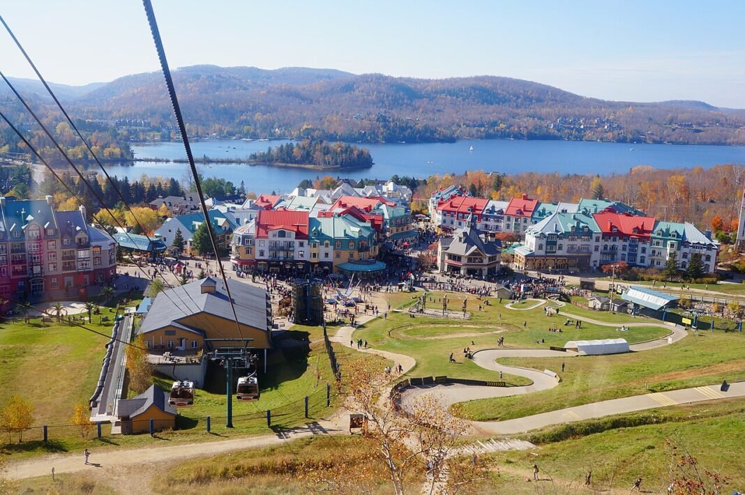
- Mont-Tremblant: The centrepiece of the Laurentians ski culture; 102 trails, a 645m (2,116 ft) vertical drop, 14 lifts, and the pedestrian resort village at the mountain’s base that stretches the ski day into an afternoon of après-ski, restaurant dining, and spa culture; consistently rated Eastern Canada’s premier ski resort; the summer mountain biking and hiking season runs on the same lift network as winter
- Mont Saint-Sauveur and the Lower Laurentians: Closer to Montreal (1 hour); smaller vertical than Tremblant but adequate for the day trip market; the cluster of lower Laurentian resorts (Morin-Heights, Mont Avila, and the Saint-Sauveur valley) forms a continuous ski-culture zone 60–90 minutes from Montreal
- Sutton and Bromont (Eastern Townships): Sutton’s 60 trails in a natural Quebec forest setting (the least artificial-feeling ski resort in the province) and Bromont’s night skiing (the largest lit ski area in North America, with roughly 90 trails illuminated each evening) round out the Townships alternative to the Laurentians
- Le Massif de Charlevoix: 4 hours from Montreal; the highest vertical drop in Eastern Canada (770m); the ski-to-the-river experience (the runs descend toward the St Lawrence) sets up a visual context unique in North American skiing
Saguenay Fjord: Kayak and Whale Watch
The Saguenay Fjord, 200km north of Quebec City where the Saguenay River joins the St Lawrence, is Quebec’s most dramatic marine environment — a fjord reaching 270m depth cut through Precambrian Shield rock, where beluga whales, minke whales, fin whales, and humpback whales congregate at the confluence of the cold, nutrient-rich fjord water and the tidal estuary:
- Sea kayaking: The Saguenay Fjord National Park protects 83km of the fjord shoreline; guided sea kayaking from Tadoussac and Baie-Sainte-Catherine puts paddlers right against the cliff walls, where the calm water and 300-metre rock faces close in to unusually intimate effect
- Whale watching: Tadoussac is the capital of the St Lawrence whale watching industry; the summer whale season (June–October) brings belugas (the St Lawrence beluga population — approximately 1,850 animals), minke, fin, humpback, and occasionally blue whales to the confluence; zodiac and large vessel tours operate from both shores
- Fjord hiking: The Sentier des Caps de Charlevoix (50km, 3 days) above the St Lawrence between Saint-Tite-des-Caps and Petite-Rivière-Saint-François delivers cliff-top views over the river; the fjord trails within Saguenay Fjord National Park (the Cap de la Boule lookout, the Anse-Saint-Jean cliff trails) open the same scenery to day hikers
The Gaspésie: Mountains and Sea

The Gaspésie Peninsula, 900km east of Montreal, combines the Chic-Chocs Mountains with the Gulf of St Lawrence coast in a destination of genuine grandeur:
- Parc national de la Gaspésie (Chic-Chocs): The Chic-Chocs are the southernmost habitat of woodland caribou in Eastern North America; Mount Albert (1,151m, one of the highest summits in southern Quebec) has an alpine plateau where caribou are reliably seen in summer; the park’s multi-day hiking circuits rank among the most demanding in the province
- Forillon National Park: The peninsula’s tip; sea cliffs above the Gulf of St Lawrence; whale watching (minke and pilot whales from the headland), seal colonies at Cap-Bon-Ami, and the International Appalachian Trail’s terminus at Cap-Gaspé; the combination of mountain and sea cliff walking is unique in Quebec
- Percé and Île Bonaventure: The Percé Rock (one of the world’s largest natural arches in a marine setting) and the Île Bonaventure northern gannet colony (120,000 birds, accessible by boat from Percé) are the Gaspésie’s most visited natural attractions; the hiking trails on Île Bonaventure bring visitors within metres of nesting gannets
Route Verte: Quebec’s Cycling Network
La Route Verte — 5,300km of designated cycling routes across Quebec — is the largest dedicated cycling network in the Americas and the foundation of Quebec’s cycling tourism industry. Key routes:
- P’tit Train du Nord (Laurentians): 234km on a former railway converted to a multi-use trail; the most iconic Quebec cycling trail, passing through 15 Laurentian communities from Saint-Jérôme to Mont-Laurier; summer cycling and winter cross-country skiing
- Corridor de l’Estrie (Eastern Townships): 110km from Granby to Bromont and beyond; rolling farmland and lake country cycling; wine stops at Dunham and Cowansville
- Vélo-Route des Bleuets (Saguenay): 256km loop around Lac Saint-Jean; flat, well-marked, and passing through the blueberry-growing heartland of Quebec; a complete cycling holiday in one of Canada’s most distinct regional cultures
- Jacques-Cartier and Portneuf trails: 68km near Quebec City; the descent into the Jacques-Cartier River valley ranks among the most dramatic rides in southern Quebec
Planning Your Outdoor Adventure
The outdoor experiences described in this guide reward practical preparation. For wilderness and protected areas, check trail conditions, permit requirements, and seasonal access with the relevant land management authority before departure — trail closures, fire restrictions, and entry quotas can change quickly, and many high-demand parks now require advance reservations that were not needed in previous years. Weather in Quebec can change rapidly, particularly in mountain terrain and during shoulder seasons; a layered approach with a waterproof outer shell is advisable for most outdoor pursuits regardless of the season. For water-based activities — paddling, snorkelling, diving, surfing — check current conditions with local outfitters who will have the most accurate and up-to-date information. Leave No Trace principles apply throughout: pack out everything you bring in, stay on established trails, give wildlife space, and leave natural features undisturbed for the next visitor.
Frequently Asked Questions
What skiing does Quebec offer and what makes Mont-Tremblant exceptional?
Quebec’s ski industry is centred on the Laurentian Mountains within two hours of Montreal. Mont-Tremblant — consistently rated Eastern Canada’s premier ski resort — offers 102 trails, a 2,116-foot vertical drop, 14 lifts, and a pedestrian resort village at the mountain’s base that extends the ski day into après-ski dining and spa culture; the summer mountain biking and hiking season mirrors the winter operation. Le Massif de Charlevoix (4 hours from Montreal) has the highest vertical drop in Eastern Canada (770m), with runs descending toward the St Lawrence — a visual context unique in North American skiing. Mont Saint-Sauveur (1 hour from Montreal) anchors the lower Laurentians day-trip ski market. Sutton (Eastern Townships) provides the least artificial-feeling ski resort in the province in a natural Quebec forest setting; Bromont operates the largest lit ski area in North America.
What does the Saguenay Fjord offer for outdoor activities and whale watching?
The Saguenay Fjord — 200km north of Quebec City, where the Saguenay River joins the St Lawrence — is Quebec’s most dramatic marine environment: a fjord reaching 270-metre depth cut through Precambrian Shield rock, where beluga, minke, fin, and humpback whales congregate at the confluence of cold fjord water and the tidal estuary. Tadoussac is the capital of the St Lawrence whale watching industry; the summer season (June–October) brings the St Lawrence beluga population (approximately 1,850 animals), minke, fin, humpback, and occasionally blue whales to the confluence; zodiac and vessel tours operate from both shores. Saguenay Fjord National Park (83km of protected fjord shoreline) runs guided sea kayaking from Tadoussac and Baie-Sainte-Catherine, where the cliff walls close in to unusually intimate effect.
What does the Gaspésie Peninsula offer for hiking and natural wonders?
The Gaspésie Peninsula (900km east of Montreal) combines the Chic-Chocs Mountains with the Gulf of St Lawrence coast. Parc national de la Gaspésie protects the Chic-Chocs — the southernmost habitat of woodland caribou in Eastern North America; Mount Albert (1,151m, one of the highest summits in southern Quebec) has an alpine plateau where caribou are reliably seen in summer. Forillon National Park, at the peninsula’s tip, pairs sea cliff hiking above the Gulf of St Lawrence with whale watching (minke and pilot whales from the headland) and seal colonies at Cap-Bon-Ami. Percé Rock — one of the world’s largest natural arches in a marine setting — and the Île Bonaventure northern gannet colony (120,000 birds, accessible by boat from Percé) are the Gaspésie’s most visited natural attractions; the island’s hiking trails bring visitors within metres of nesting gannets.
What is La Route Verte and what does Quebec cycling offer?
La Route Verte — 5,300km of designated cycling routes across Quebec — is the largest dedicated cycling network in the Americas and the foundation of Quebec’s cycling tourism. The P’tit Train du Nord (234km, Saint-Jérôme to Mont-Laurier, former railway converted to multi-use trail) is the most iconic Quebec cycling trail, passing through 15 Laurentian communities — summer cycling and winter cross-country skiing on the same corridor. The Vélo-Route des Bleuets (256km loop around Lac Saint-Jean) is a complete cycling holiday through the blueberry-growing heartland of Quebec. The Corridor de l’Estrie (110km, Granby to Bromont) provides rolling Eastern Townships farmland and lake country cycling with wine stops at Dunham and Cowansville. The Jacques-Cartier and Portneuf trails (68km near Quebec City) descend into the Jacques-Cartier River valley in one of the most dramatic cycling experiences in southern Quebec.
What other parks and outdoor destinations does Quebec offer?
Jacques-Cartier National Park, 40km north of Quebec City, provides the premier wilderness experience accessible from a Quebec provincial capital — the deep U-shaped valley carved by glaciers is home to moose, white-tailed deer, and brook trout, with hiking, kayaking, and cycling trails along the Jacques-Cartier River. The Sentier des Caps de Charlevoix (50km, 3 days) above the St Lawrence between Saint-Tite-des-Caps and Petite-Rivière-Saint-François delivers cliff-top views over the river — the finest multi-day trail in the Quebec City region. Mont-Mégantic National Park (Eastern Townships) is the first International Dark Sky Reserve in the world (designated 2007), combining the Astrolab observatory’s public astronomy programs with exceptional wildlife viewing and Appalachian hiking. Quebec’s winter outdoor culture — the Carnaval de Québec in February and the Igloofest electronic music festival on the Montreal waterfront in January — celebrates winter rather than merely enduring it.