
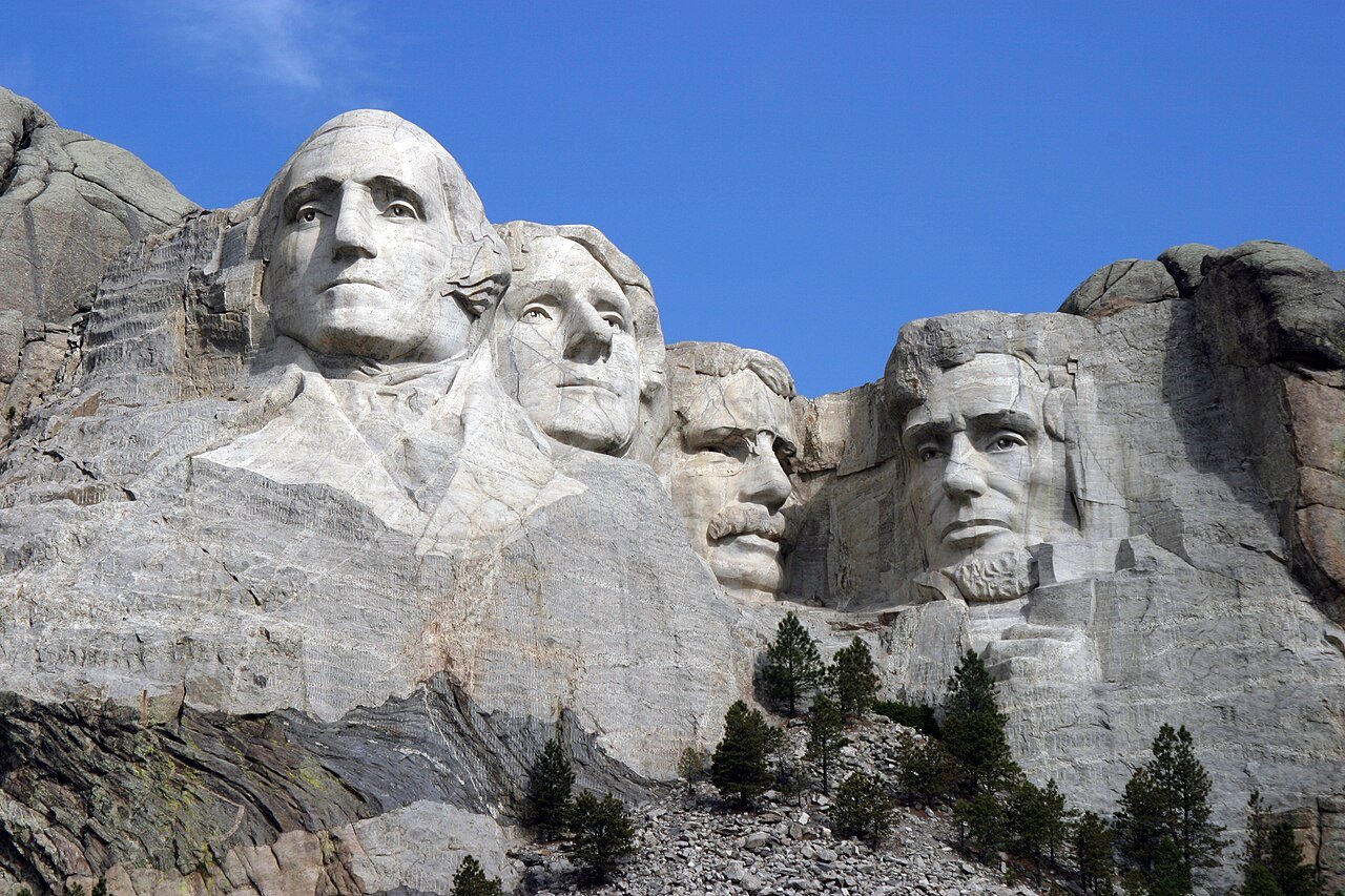
South Dakota’s outdoor recreation is anchored by two landscapes that share almost nothing — the Badlands’ eroded moonscape of spires and buttes in the southwest, and the forested Black Hills rising like a green island from the surrounding prairie. Beyond them, the Missouri River reservoir system delivers fishing and boating, the Glacial Lakes region holds dense wetland ecology, and open-sky prairie covers the eastern half of the state. Western South Dakota packs Badlands National Park, Custer State Park, Wind Cave National Park, and Jewel Cave National Monument into a single corner, a concentration of major outdoor attractions that few comparable areas can match.
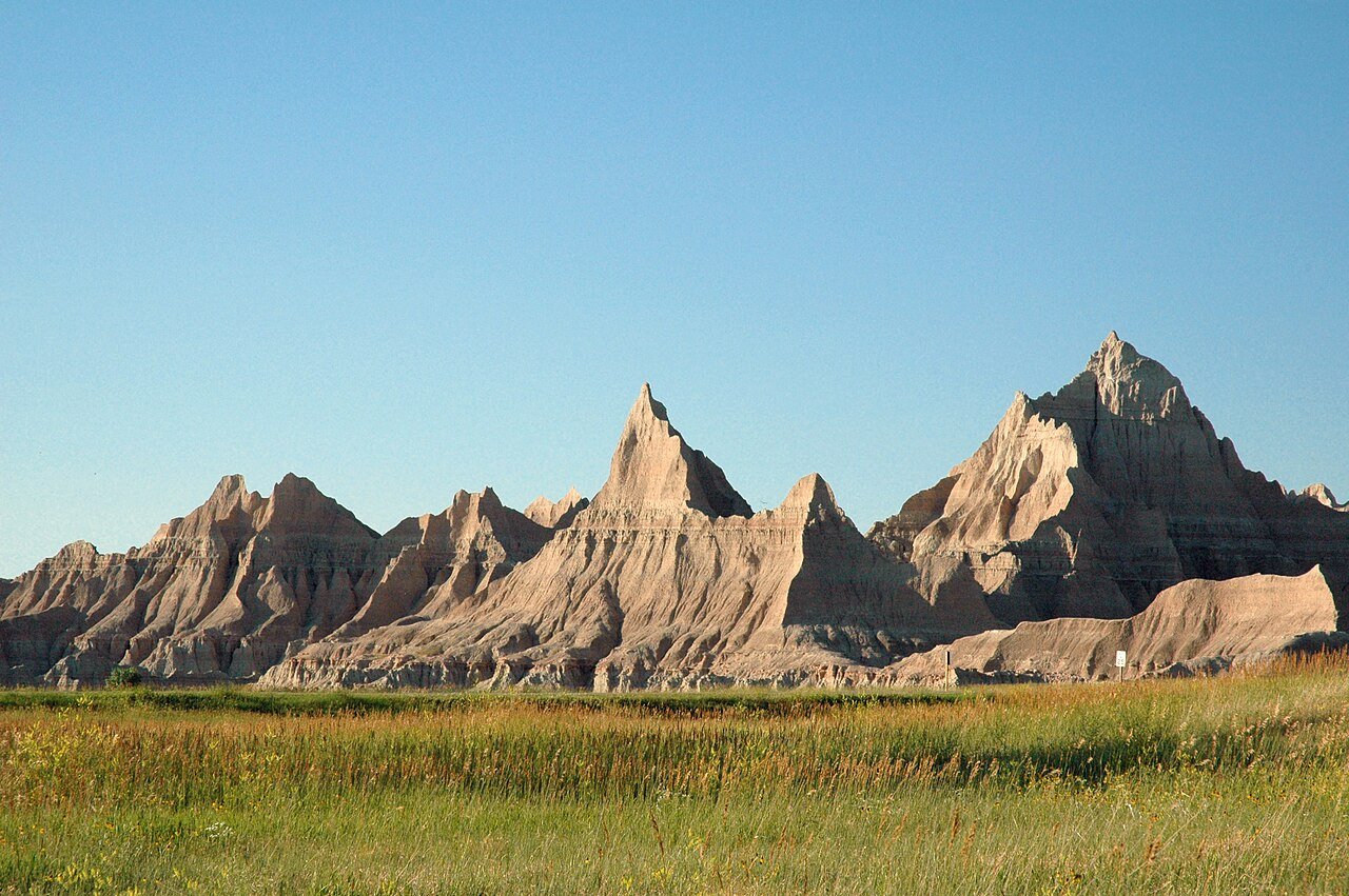
Badlands National Park: The Fossil Badlands
Badlands National Park rewards anyone willing to leave the Loop Road’s obvious overlooks. The backcountry is open for off-trail hiking with minimal regulation, which lets you read the formations at a scale no roadside viewpoint can offer. The Sage Creek Wilderness Area, in the park’s western section, holds the most solitude and the best bison viewing, reached by the unpaved Sage Creek Road into one of the most remote, least-visited stretches of the national park system — and all of it sits within 50 miles of Rapid City.
- Stargazing: some of the darkest skies in the country — the park is pursuing International Dark Sky certification, and the Milky Way is visible to the naked eye on most clear nights
- Fossil hunting: ranger-led fossil walks reveal 34-million-year-old horse and rhino ancestors
- Wildlife: bison, pronghorn, bighorn sheep, black-footed ferrets (reintroduced), and swift fox all live in the park
- Photography: sunrise at the Big Badlands Overlook ranks among the best landscape shots in the American West
Custer State Park: Black Hills Wildlife Refuge
Custer State Park covers 71,000 acres of Black Hills country — granite needles, pine forest, mountain meadows, and the Sylvan Lake recreation area — built around a free-roaming herd of more than 1,300 bison, among the largest publicly owned herds anywhere. The 18-mile Wildlife Loop Road offers the best vehicle-accessible bison viewing on the Great Plains, and the annual buffalo roundup in late September pulls some 20,000 spectators to watch riders and helicopters work the herd. The Needles Highway, a paved road threading between towering granite pinnacles, ranks among the most striking scenic drives in the region.
Wind Cave National Park: Underground Wilderness
Wind Cave National Park, next door to Custer State Park, protects the densest cave system on Earth — more than 160 miles of mapped passages packed into a volume of rock smaller than many office buildings. Its signature feature is boxwork: rare calcium carbonate fins that honeycomb the cave walls in geometric patterns found at this quality almost nowhere else. Ranger-led tours run from 30 minutes (the Candlelight Tour by lantern light) to four hours (the Wild Cave Tour, with crawling and climbing), each reaching a different side of the cave’s geology. Above ground, mixed-grass prairie and ponderosa pine woodland support bison, elk, pronghorn, and prairie dogs, often visible right from the park roads.
Mickelson Trail: Biking the Black Hills
The George S. Mickelson Trail runs 109 miles through the heart of the Black Hills, following abandoned railroad grades past pine forest, granite canyons, and old mining towns from Edgemont in the south to Deadwood in the north. Because it traces a rail line, the grade never tops 4 percent, which keeps it open to casual cyclists and families while the full distance still challenges stronger riders. The route threads four tunnels and crosses more than 100 converted railroad bridges, with trailhead towns supplying lodging and services along the way.
Missouri River Fishing and Water Recreation
The Missouri River reservoir chain — Lakes Oahe, Sharpe, Francis Case, and Lewis and Clark — runs more than 400 miles across south-central South Dakota, holding walleye, smallmouth bass, northern pike, and channel catfish that pull anglers from across the upper Midwest. Lake Oahe, the fourth-largest reservoir in the United States, stretches 231 miles from Pierre to Bismarck, North Dakota, with walleye fishing that stands up to any freshwater destination in the country. Farther northeast, the state’s 3,000-plus Glacial Lakes provide pheasant habitat and waterfowl staging grounds of national importance.
South Dakota’s outdoor calendar shifts with the seasons. Spring (April to May) brings prairie wildflowers and waterfowl migrating through the Glacial Lakes. Summer (June to August) is peak Black Hills time, with hiking, mountain biking, and crowds dense enough that early mornings and weekdays pay off for serious exploring. Fall (September to October) is the sweet spot for both the Badlands and the Black Hills — fewer people, comfortable temperatures, and the golden mixed-grass prairie that gives the landscape a warmth no other season matches. Winter opens cross-country skiing in the hills, ice fishing on the reservoirs, and the dark, clear skies that make this one of the best stargazing regions in the lower 48.
Planning Your Outdoor Adventure
The trips described in this guide reward a little practical preparation. For wilderness and protected areas, check trail conditions, permit requirements, and seasonal access with the managing land agency before you set out — closures, fire restrictions, and entry quotas can change fast, and many high-demand parks now require advance reservations that weren’t needed a few years ago. Weather here turns quickly, especially in mountain terrain and the shoulder seasons, so a layered setup with a waterproof outer shell makes sense for most outings. For anything on the water — paddling, fishing, boating — check current conditions with local outfitters, who tend to have the most accurate read. Leave No Trace principles apply throughout: pack out everything you bring in, stay on established trails, give wildlife room, and leave natural features as you found them.
Frequently Asked Questions
What does Badlands National Park offer for outdoor exploration beyond the loop road?
Badlands National Park’s backcountry allows off-trail hiking without formal trails or permits — the most direct way to experience the formations at a scale no roadside viewpoint can match. The Sage Creek Wilderness Area, in the park’s western section, holds the most solitude and the best bison viewing, reached via the unpaved Sage Creek Road. With some of the darkest skies in the country — the park is pursuing International Dark Sky certification — it shows the Milky Way to the naked eye on most clear nights, ranking among the best stargazing spots in the American West. Ranger-led fossil walks reveal 34-million-year-old horse and rhino ancestors, and the park supports bison, pronghorn, bighorn sheep, black-footed ferrets (reintroduced), and swift fox. Sunrise at the Big Badlands Overlook is among the strongest landscape photography opportunities in the region.
What is Custer State Park and what makes it one of America’s best state parks?
Custer State Park covers 71,000 acres of Black Hills landscape in southwestern South Dakota, taking in granite needles, pine forest, mountain meadows, and Sylvan Lake, all built around a free-roaming herd of more than 1,300 bison — among the largest publicly owned herds anywhere. The 18-mile Wildlife Loop Road offers the best vehicle-accessible bison viewing on the Great Plains, and the annual buffalo roundup in late September draws about 20,000 spectators to watch riders and helicopters work the herd. The Needles Highway threads between towering granite pinnacles on one of the region’s most striking scenic drives, and the short Cathedral Spires Trail (about 1.5 miles round trip) climbs to the park’s most dramatic granite formations.
What is Wind Cave National Park and what are its distinctive geological features?
Wind Cave National Park, next to Custer State Park, protects the densest cave system on Earth — more than 160 miles of mapped passages. Its signature feature is boxwork: rare calcium carbonate fins honeycombing the cave walls in geometric patterns found at this quality almost nowhere else. Ranger-led tours range from 30 minutes (the Candlelight Tour by lantern light) to four hours (the Wild Cave Tour, with crawling and climbing), each reaching a different side of the cave’s geology. Above ground, the park supports bison, elk, pronghorn, and prairie dogs. It takes its name from the barometric winds that blow through the cave entrance as atmospheric pressure changes — the cave’s vast network acts as a natural pressure-equalization system, producing predictable wind direction based on relative pressure.
What is the Mickelson Trail and what does Black Hills cycling offer?
The George S. Mickelson Trail runs 109 miles through the heart of the Black Hills, following abandoned railroad grades (never steeper than 4 percent) from Edgemont in the south to Deadwood in the north, past pine forest, granite canyons, and old mining towns. The gentle grade keeps it open to casual cyclists and families, while the full distance challenges stronger riders. The route threads four tunnels and crosses more than 100 converted railroad bridges. The wider Black Hills trail system links to Deadwood (walking distance from its Wild West heritage district), Lead (home of the former Homestake Gold Mine, the largest gold mine in North America for over a century), and the mountain biking network around Deerfield Lake in the national forest.
What fishing and water recreation does South Dakota offer?
The Missouri River reservoir chain — Lakes Oahe, Sharpe, Francis Case, and Lewis and Clark — runs more than 400 miles across south-central South Dakota, holding walleye, smallmouth bass, northern pike, and channel catfish that draw anglers from across the upper Midwest. Lake Oahe (the fourth-largest reservoir in the United States, stretching 231 miles from Pierre to Bismarck, North Dakota) offers walleye fishing that stands up to any freshwater destination in the country. Farther northeast, the state’s 3,000-plus Glacial Lakes provide strong pheasant habitat and waterfowl staging grounds of national importance, helping make South Dakota a leading pheasant hunting destination.

